
Topografische kaart Coqueiro Seco
Interactieve kaart
Klik op de kaart om de hoogte weer te geven.
Over deze kaart
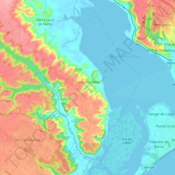
Naam: Topografische kaart Coqueiro Seco, hoogte, reliëf.
Gemiddelde hoogte: 37 m
Minimale hoogte: -3 m
Maximale hoogte: 111 m
The history account that some years later came to the region several missionaries of the order of Franciscans, which delighted up with the topography of the place, which had plans ups and downs, changing its name to Monte Santo. Get accustomed with the old name of the city, the people ignored the Franciscans and retained the name of Coqueiro Seco.
Andere topografische kaarten
Klik op een kaart om zijn topografie, zijn hoogte en zijn reliëf te bekijken.
Pão de Açúcar
Pão de Açúcar, Região Geográfica Imediata de Pão de Açúcar-Olho d'Água das Flores-Batalha, Região Geográfica Intermediária de Arapiraca, Alagoas, Northeast Region, 57400-000, Brazil
Gemiddelde hoogte: 181 m
Praia do Gunga
Praia do Gunga, Roteiro, Região Geográfica Imediata de São Miguel dos Campos, Região Geográfica Intermediária de Maceió, Alagoas, Northeast Region, Brazil
Gemiddelde hoogte: 6 m
Campo Alegre
Campo Alegre, Região Geográfica Imediata de São Miguel dos Campos, Região Geográfica Intermediária de Maceió, Alagoas, Northeast Region, Brazil
Gemiddelde hoogte: 160 m
Campo Alegre
Brazil > Alagoas > Campo Alegre
Campo Alegre, Microrregião de São Miguel dos Campos, Mesorregião Leste Alagoano, Alagoas, Northeast Region, Brazil
Gemiddelde hoogte: 139 m