
Topografische kaart Salisbury
Interactieve kaart
Klik op de kaart om de hoogte weer te geven.
Salisbury
According to the United States Census Bureau, the city has a total area of 13.87 square miles (35.92 km2), of which 13.40 square miles (34.71 km2) is land and 0.47 square miles (1.22 km2) is water. The city has a varying elevation of 17 to 45 feet (5.2 to 13.7 m) above sea level.
Over deze kaart
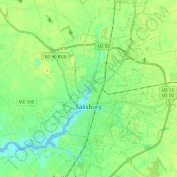
Naam: Topografische kaart Salisbury, hoogte, reliëf.
Locatie: Salisbury, Wicomico County, Maryland, United States (38.32695 -75.64292 38.42711 -75.50357)
Gemiddelde hoogte: 12 m
Minimale hoogte: -3 m
Maximale hoogte: 30 m
Andere topografische kaarten
Klik op een kaart om zijn topografie, zijn hoogte en zijn reliëf te bekijken.
Salisbury
United States > Maryland > Wicomico County > Salisbury
According to the United States Census Bureau, the city has a total area of 13.87 square miles (35.92 km2), of which 13.40 square miles (34.71 km2) is land and 0.47 square miles (1.22 km2) is water. The city has a varying elevation of 17 to 45 feet (5.2 to 13.7 m) above sea level.
Gemiddelde hoogte: 11 m