
Topografische kaart Fruita
Interactieve kaart
Klik op de kaart om de hoogte weer te geven.
Over deze kaart
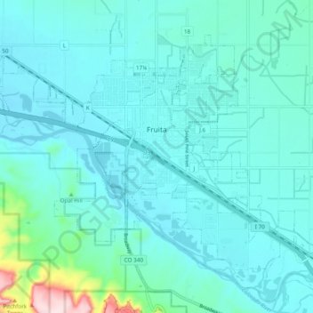
Naam: Topografische kaart Fruita, hoogte, reliëf.
Locatie: Fruita, Mesa County, Colorado, 81521, United States (39.12384 -108.77758 39.18116 -108.68241)
Gemiddelde hoogte: 1.400 m
Minimale hoogte: 1.355 m
Maximale hoogte: 1.719 m
The original town site was planned for 80 acres (32 ha) with a park in the middle. The first water reached the town from the Colorado River in 1907. By 1909, the town center was linked with electricity. In the 1930s, Fruita participated in several government projects, including the Grand Valley Resettlement Project (later Western Slope Farms). Settled in groups of two or three families per area, 34 families were relocated by 1937. Later, the Rural Electrification Project brought electricity to around 800 or 900 farms. Fruita also had a Civilian Conservation Corps, several Works Progress Administration projects including the town library (now the Chamber of Commerce), a federal loan for the new central school (now the Civic Center) and the construction of the spectacular Rim Rock Drive to the top of the Colorado National Monument, elevation 8,000 feet (2,400 m). Today, the historic activities of Fruita are supported by the efforts of the Fruita Historic Preservation Board and the Lower Valley Heritage Chapter.
Andere topografische kaarten
Klik op een kaart om zijn topografie, zijn hoogte en zijn reliëf te bekijken.
Grand Mesa
United States > Colorado > Mesa County
Grand Mesa, Mesa County, Colorado, United States
Gemiddelde hoogte: 2.666 m
Colorado River
United States > Colorado > Mesa County
Colorado River, Mesa County, Colorado, 81504, United States
Gemiddelde hoogte: 1.417 m
Clifton
United States > Colorado > Mesa County
Clifton, Mesa County, Colorado, 81520, United States
Gemiddelde hoogte: 1.431 m
Molina
United States > Colorado > Mesa County
Molina, Mesa County, Colorado, 81646, United States
Gemiddelde hoogte: 1.794 m
Grand Junction
United States > Colorado > Mesa County
Grand Junction, Mesa County, Colorado, United States
Gemiddelde hoogte: 1.470 m
De Beque
United States > Colorado > Mesa County
De Beque, Mesa County, Colorado, United States
Gemiddelde hoogte: 1.597 m
Colorado National Monument
United States > Colorado > Mesa County
Colorado National Monument, Mesa County, Colorado, United States
Gemiddelde hoogte: 1.809 m
Glade Park
United States > Colorado > Mesa County
Glade Park, Mesa County, Colorado, 81523, United States
Gemiddelde hoogte: 2.110 m
Bell Tower (Kissing Couple)
United States > Colorado > Mesa County
Bell Tower (Kissing Couple), Mesa County, Colorado, United States
Gemiddelde hoogte: 1.711 m
Palisade
United States > Colorado > Mesa County
Palisade, Mesa County, Colorado, 81526, United States
Gemiddelde hoogte: 1.486 m
Collbran
United States > Colorado > Mesa County
Collbran, Mesa County, Colorado, United States
Gemiddelde hoogte: 1.882 m
The Flat Tops
United States > Colorado > Mesa County
The Flat Tops, Mesa County, Colorado, United States
Gemiddelde hoogte: 3.207 m