
Topografische kaart Villalba
Interactieve kaart
Klik op de kaart om de hoogte weer te geven.
Over deze kaart
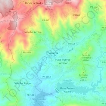
Naam: Topografische kaart Villalba, hoogte, reliëf.
Locatie: Villalba, Puerto Rico, 00766, United States (18.08835 -66.53250 18.16835 -66.45250)
Gemiddelde hoogte: 406 m
Minimale hoogte: 97 m
Maximale hoogte: 1.086 m
Villalba is located in the central region of Puerto Rico, on a valley in the Cordillera Central. The highest point in the municipality is Cerro El Bolo at 3,526 feet (1,075 m) of elevation.