
Doe een donatie
Rust jezelf uit voor je volgende avontuur:
Als Amazon-partner verdient deze site een commissie op in aanmerking komende aankopen, zonder extra kosten voor jou.
Topografische kaart Monte Titano
Klik op de kaart om de hoogte weer te geven.
Doe een donatie
Rust jezelf uit voor je volgende avontuur:
Als Amazon-partner verdient deze site een commissie op in aanmerking komende aankopen, zonder extra kosten voor jou.
Monte Titano
Set in the Mediterranean zone the vegetation is typical influenced by elevation variations. Numerous trees inhabit the mountain, including chestnuts, oaks, laburnum, cypress, fir trees and some shrubs and asparagus, typical of the driest areas, such as the territory in the Three Towers of San Marino vicinity. On the cliffs of Mount Titano is also found Ephedra Nebrodensis, a plant typical of Sicily and Sardinia.
Doe een donatie
Rust jezelf uit voor je volgende avontuur:
Als Amazon-partner verdient deze site een commissie op in aanmerking komende aankopen, zonder extra kosten voor jou.
Over deze kaart
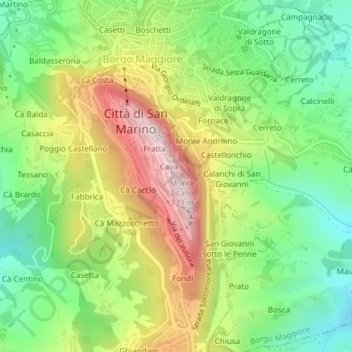
Naam: Topografische kaart Monte Titano, hoogte, reliëf.
Locatie: Monte Titano, City of San Marino, 47890, San Marino (43.93223 12.45160 43.93233 12.45170)
Gemiddelde hoogte: 434 m
Minimale hoogte: 236 m
Maximale hoogte: 708 m
Doe een donatie
Rust jezelf uit voor je volgende avontuur:
Als Amazon-partner verdient deze site een commissie op in aanmerking komende aankopen, zonder extra kosten voor jou.