
Topografische kaart Iłża
Interactieve kaart
Klik op de kaart om de hoogte weer te geven.
Over deze kaart
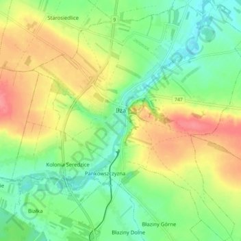
Naam: Topografische kaart Iłża, hoogte, reliëf.
Gemiddelde hoogte: 204 m
Minimale hoogte: 174 m
Maximale hoogte: 244 m
Andere topografische kaarten
Klik op een kaart om zijn topografie, zijn hoogte en zijn reliëf te bekijken.
Pionki
Poland > Masovian Voivodeship > Radom County
Pionki, Radom County, Masovian Voivodeship, Poland
Gemiddelde hoogte: 159 m
Zatopolice
Poland > Masovian Voivodeship > Radom County > Zatopolice
Zatopolice, gmina Zakrzew, Radom County, Masovian Voivodeship, Poland
Gemiddelde hoogte: 188 m