
Topografische kaart Montclaire South
Interactieve kaart
Klik op de kaart om de hoogte weer te geven.
Over deze kaart
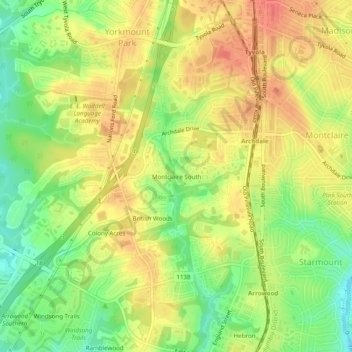
Naam: Topografische kaart Montclaire South, hoogte, reliëf.
Gemiddelde hoogte: 202 m
Minimale hoogte: 169 m
Maximale hoogte: 228 m
Andere topografische kaarten
Klik op een kaart om zijn topografie, zijn hoogte en zijn reliëf te bekijken.
Providence Plantation
United States > North Carolina > Mecklenburg County > Charlotte
Providence Plantation, Charlotte, Mecklenburg County, North Carolina, United States
Gemiddelde hoogte: 205 m
Manchester
United States > North Carolina > Mecklenburg County > Charlotte
Manchester, Charlotte, Mecklenburg County, North Carolina, United States
Gemiddelde hoogte: 234 m
Grierview
United States > North Carolina > Mecklenburg County > Charlotte
Grierview, Charlotte, Mecklenburg County, North Carolina, 28126, United States
Gemiddelde hoogte: 232 m
Coulwood Hills
United States > North Carolina > Mecklenburg County > Charlotte > Coulwood Hills
Coulwood Hills, Charlotte, Mecklenburg County, North Carolina, 28214, United States
Gemiddelde hoogte: 213 m
Providence Plantation
United States > North Carolina > Mecklenburg County > Charlotte > Providence Plantation
Providence Plantation, Charlotte, Mecklenburg County, North Carolina, 28270, United States
Gemiddelde hoogte: 200 m