
Topografische kaart Panaji
Interactieve kaart
Klik op de kaart om de hoogte weer te geven.
Over deze kaart
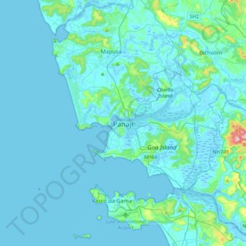
Naam: Topografische kaart Panaji, hoogte, reliëf.
Locatie: Panaji, Tiswadi, North Goa District, Goa, 403001, India (15.33899 73.66821 15.65899 73.98821)
Gemiddelde hoogte: 19 m
Minimale hoogte: -3 m
Maximale hoogte: 285 m
Panaji was annexed by India with the rest of Goa and the former Portuguese territories after the Indian annexation of Portuguese India in 1961. It became a state-capital on Goa's elevation to statehood in 1987. Between 1961 and 1987, it was the capital of the Union Territory of Goa, Daman and Diu. A new Legislative Assembly complex was inaugurated in March 2000, across the Mandovi River, in Alto Porvorim. Panaji is also the administrative headquarters of North Goa district.
Andere topografische kaarten
Klik op een kaart om zijn topografie, zijn hoogte en zijn reliëf te bekijken.
Divar Island
India > Goa > Tiswadi > Piedade
Divar Island, Piedade, Tiswadi, North Goa District, Goa, India
Gemiddelde hoogte: 11 m
Miramar beach
India > Goa > Tiswadi > Panaji
Miramar beach, Dr. Jack Sequeira Road, St. Mary's Colony, Miramar, Panaji, Tiswadi, North Goa District, Goa, 403004, India
Gemiddelde hoogte: 3 m
Miramar Beach
India > Goa > Tiswadi > Panaji
Miramar Beach, Miramar, Panaji, Tiswadi, North Goa, Goa, India
Gemiddelde hoogte: 3 m
Carambolim
Carambolim, Tiswadi, North Goa District, Goa, 403110, India
Gemiddelde hoogte: 17 m