
Topografische kaart Roosevelt Island
Interactieve kaart
Klik op de kaart om de hoogte weer te geven.
Over deze kaart
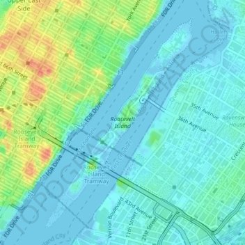
Naam: Topografische kaart Roosevelt Island, hoogte, reliëf.
Gemiddelde hoogte: 13 m
Minimale hoogte: -6 m
Maximale hoogte: 52 m
Andere topografische kaarten
Klik op een kaart om zijn topografie, zijn hoogte en zijn reliëf te bekijken.
Central Park
United States > New York > New York County > New York
Central Park, New York County, New York, United States
Gemiddelde hoogte: 26 m
Manhattan
United States > New York > New York County > New York
Manhattan, New York County, New York, United States
Gemiddelde hoogte: 16 m
Governors Island
United States > New York > New York County > New York
Governors Island, Manhattan, New York County, New York, United States
Gemiddelde hoogte: 1 m
Battery Park
United States > New York > New York County > New York
Battery Park, Financial District, Manhattan, New York County, New York, 10004, United States
Gemiddelde hoogte: 3 m
Highbridge Park
United States > New York > New York County > New York
Highbridge Park, Manhattan, New York County, New York, United States
Gemiddelde hoogte: 30 m
Manhattan Community Board 3
United States > New York > New York County > New York
Manhattan Community Board 3, Manhattan, New York County, New York, United States, Seward Park
Gemiddelde hoogte: 10 m
Hunter’s Point South Waterfront Park
United States > New York > New York County > New York
Hunter’s Point South Waterfront Park, Manhattan Community Board 6, Manhattan, New York County, New York, United States
Gemiddelde hoogte: 5 m