
Topografische kaart Umawera
Interactieve kaart
Klik op de kaart om de hoogte weer te geven.
Over deze kaart
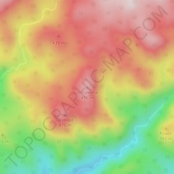
Naam: Topografische kaart Umawera, hoogte, reliëf.
Gemiddelde hoogte: 309 m
Minimale hoogte: 45 m
Maximale hoogte: 511 m
Andere topografische kaarten
Klik op een kaart om zijn topografie, zijn hoogte en zijn reliëf te bekijken.
Horeke
New Zealand > Kaikohe-Hokianga Community > Horeke
Horeke, Kaikohe-Hokianga Community, Far North District, Northland, 0491, New Zealand
Gemiddelde hoogte: 46 m
Waimate North
New Zealand > Kaikohe-Hokianga Community > Waimate North
Waimate North, Kaikohe-Hokianga Community, Far North District, Northland, New Zealand
Gemiddelde hoogte: 149 m
Omanaia
New Zealand > Kaikohe-Hokianga Community
Omanaia, Kaikohe-Hokianga Community, Far North District, Northland, New Zealand
Gemiddelde hoogte: 39 m
Awaroa River
New Zealand > Kaikohe-Hokianga Community
Awaroa River, Kaikohe-Hokianga Community, Far North District, Northland, 0496, New Zealand
Gemiddelde hoogte: 62 m
Rawene
New Zealand > Kaikohe-Hokianga Community > Rawene
Rawene, Kaikohe-Hokianga Community, Far North District, Northland, 0452, New Zealand
Gemiddelde hoogte: 8 m
Omapere
New Zealand > Kaikohe-Hokianga Community > Omapere
Omapere, Kaikohe-Hokianga Community, Far North District, Northland, 0444, New Zealand
Gemiddelde hoogte: 68 m
Mangamuka River
New Zealand > Kaikohe-Hokianga Community
Mangamuka River, Kaikohe-Hokianga Community, Far North District, Northland, 0453, New Zealand
Gemiddelde hoogte: 100 m
Waimamaku River
New Zealand > Kaikohe-Hokianga Community
Waimamaku River, Kaikohe-Hokianga Community, Far North District, Northland, 0444, New Zealand
Gemiddelde hoogte: 281 m