
Topografische kaart Ayodhya
Interactieve kaart
Klik op de kaart om de hoogte weer te geven.
Over deze kaart
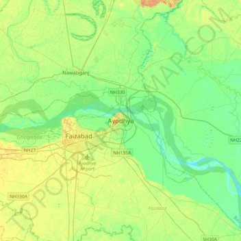
Naam: Topografische kaart Ayodhya, hoogte, reliëf.
Locatie: Ayodhya, Faizabad, Uttar Pradesh, 224123, India (26.75907 82.16523 26.83907 82.24523)
Gemiddelde hoogte: 94 m
Minimale hoogte: 86 m
Maximale hoogte: 109 m
The earliest of the Buddhist Pali-language texts and the Jain Prakrit-language texts mention a city called Saketa (Sageya or Saeya in Prakrit) as an important city of the Kosala mahajanapada. Topographical indications in both Buddhist and Jain texts suggest that Saketa is the same as the present-day Ayodhya. For example, according to the Samyutta Nikaya and the Vinaya Pitaka, Saketa was located at a distance of six yojanas from Shravasti. The Vinaya Pitaka mentions that a big river was located between the two cities, and the Sutta Nipata mentions Saketa as the first halting place on the southward road from Shravasti to Pratishthana.
Andere topografische kaarten
Klik op een kaart om zijn topografie, zijn hoogte en zijn reliëf te bekijken.