
Topografische kaart Alexandria
Interactieve kaart
Klik op de kaart om de hoogte weer te geven.
Over deze kaart
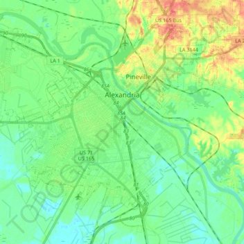
Naam: Topografische kaart Alexandria, hoogte, reliëf.
Gemiddelde hoogte: 26 m
Minimale hoogte: 11 m
Maximale hoogte: 58 m
Alexandria is located at 31°17′34″N 92°27′33″W / 31.29278°N 92.45917°W / 31.29278; -92.45917 and has an elevation of 75 feet (22.9 m).