
Topografische kaart West Dundee
Interactieve kaart
Klik op de kaart om de hoogte weer te geven.
Over deze kaart
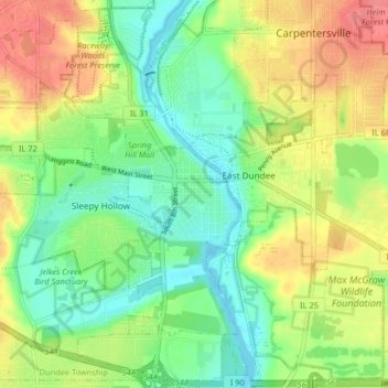
Naam: Topografische kaart West Dundee, hoogte, reliëf.
Gemiddelde hoogte: 248 m
Minimale hoogte: 217 m
Maximale hoogte: 291 m
Andere topografische kaarten
Klik op een kaart om zijn topografie, zijn hoogte en zijn reliëf te bekijken.
Elgin
United States > Illinois > Kane County
Elgin, Elgin Township, Kane County, Illinois, United States
Gemiddelde hoogte: 250 m
Batavia
United States > Illinois > Kane County > Batavia
Batavia, Batavia Township, Kane County, Illinois, United States
Gemiddelde hoogte: 224 m
Carpentersville
United States > Illinois > Kane County
Carpentersville, Dundee Township, Kane County, Illinois, United States
Gemiddelde hoogte: 253 m
Geneva
United States > Illinois > Kane County
Geneva, Geneva Township, Kane County, Illinois, 60134, United States
Gemiddelde hoogte: 229 m
Aurora
United States > Illinois > Kane County > Aurora
Aurora, Aurora Township, Kane County, Illinois, 60505, United States
Gemiddelde hoogte: 216 m
St. Charles
United States > Illinois > Kane County > St. Charles
St. Charles, Kane County, Illinois, United States
Gemiddelde hoogte: 234 m
Plato Township
United States > Illinois > Kane County > Plato Township
Plato Township, Kane County, Illinois, United States
Gemiddelde hoogte: 283 m
Aurora
United States > Illinois > Kane County
Aurora, Aurora Township, Kane County, Illinois, United States
Gemiddelde hoogte: 212 m