
Topografische kaart Clarksburg
Interactieve kaart
Klik op de kaart om de hoogte weer te geven.
Over deze kaart
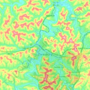
Naam: Topografische kaart Clarksburg, hoogte, reliëf.
Locatie: Clarksburg, Harrison County, West Virginia, United States (39.24993 -80.40078 39.33619 -80.24495)
Gemiddelde hoogte: 347 m
Minimale hoogte: 275 m
Maximale hoogte: 475 m
Clarksburg is located at the junction of U.S. 50 and U.S. 19, two miles west of the junction of U.S. 50 with Interstate 79. The city lies at an elevation of 1,007 feet at the junction of Elk Creek and the West Fork River of the Monongahela River.
Andere topografische kaarten
Klik op een kaart om zijn topografie, zijn hoogte en zijn reliëf te bekijken.
Nutter Fort
United States > West Virginia > Harrison County
Nutter Fort, Harrison County, West Virginia, United States
Gemiddelde hoogte: 332 m
Clarksburg
United States > West Virginia > Harrison County
Clarksburg, Harrison County, West Virginia, 26301, United States
Gemiddelde hoogte: 366 m
Clarksburg City Park
United States > West Virginia > Harrison County > Nutter Fort
Clarksburg City Park, Nutter Fort, Harrison County, West Virginia, United States
Gemiddelde hoogte: 335 m
Haywood
United States > West Virginia > Harrison County
Haywood, Harrison County, West Virginia, 26366, United States
Gemiddelde hoogte: 328 m
Viropa
United States > West Virginia > Harrison County
Viropa, Harrison County, West Virginia, 26568, United States
Gemiddelde hoogte: 333 m