
Topografische kaart Muskego
Interactieve kaart
Klik op de kaart om de hoogte weer te geven.
Over deze kaart
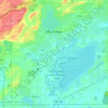
Naam: Topografische kaart Muskego, hoogte, reliëf.
Locatie: Muskego, Waukesha County, Wisconsin, 53150, United States (42.84282 -88.19581 42.93012 -88.06949)
Gemiddelde hoogte: 248 m
Minimale hoogte: 231 m
Maximale hoogte: 310 m
Andere topografische kaarten
Klik op een kaart om zijn topografie, zijn hoogte en zijn reliëf te bekijken.
Kettle Moraine State Forest - Lapham Peak Unit
United States > Wisconsin > Waukesha County > Delafield
Kettle Moraine State Forest - Lapham Peak Unit, W329 N846, South Cushing Park Road, Delafield, Town of Delafield, Waukesha County, Wisconsin, 53018, United States
Gemiddelde hoogte: 306 m
Hartland
United States > Wisconsin > Waukesha County
Hartland, Waukesha County, Wisconsin, United States
Gemiddelde hoogte: 289 m
Town of Brookfield
United States > Wisconsin > Waukesha County
Town of Brookfield, Waukesha County, Wisconsin, United States
Gemiddelde hoogte: 263 m
Oconomowoc
United States > Wisconsin > Waukesha County
Oconomowoc, Waukesha County, Wisconsin, United States
Gemiddelde hoogte: 267 m
Menomonee Falls
United States > Wisconsin > Waukesha County > Menomonee Falls
Menomonee Falls, Waukesha County, Wisconsin, 53051, United States
Gemiddelde hoogte: 260 m
Town of Delafield
United States > Wisconsin > Waukesha County > Town of Delafield
Town of Delafield, Waukesha County, Wisconsin, United States
Gemiddelde hoogte: 291 m
Delafield
United States > Wisconsin > Waukesha County > Delafield
Delafield, Waukesha County, Wisconsin, 53018, United States
Gemiddelde hoogte: 283 m
Mukwonago Park
United States > Wisconsin > Waukesha County
Mukwonago Park, Town of Mukwonago, Waukesha County, Wisconsin, 53149, United States
Gemiddelde hoogte: 267 m
Wales
United States > Wisconsin > Waukesha County
Wales, Waukesha County, Wisconsin, 53183, United States
Gemiddelde hoogte: 302 m
Waukesha
United States > Wisconsin > Waukesha County
Waukesha, Waukesha County, Wisconsin, United States
Gemiddelde hoogte: 268 m
Brookfield
United States > Wisconsin > Waukesha County > Brookfield
Brookfield, Waukesha County, Wisconsin, United States
Gemiddelde hoogte: 251 m
Sussex
United States > Wisconsin > Waukesha County
Sussex, Waukesha County, Wisconsin, 53089, United States
Gemiddelde hoogte: 286 m
Village of Pewaukee
United States > Wisconsin > Waukesha County > Village of Pewaukee
Village of Pewaukee, Waukesha County, Wisconsin, 53072, United States
Gemiddelde hoogte: 269 m