
Topografische kaart Saint Johnsbury
Interactieve kaart
Klik op de kaart om de hoogte weer te geven.
Over deze kaart
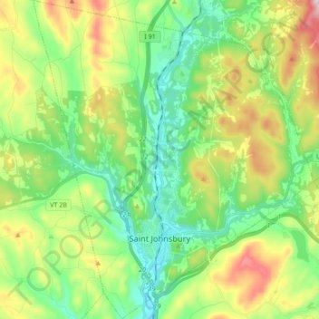
Naam: Topografische kaart Saint Johnsbury, hoogte, reliëf.
Locatie: Saint Johnsbury, Caledonia County, Vermont, United States (44.38845 -72.08354 44.51037 -71.93322)
Gemiddelde hoogte: 311 m
Minimale hoogte: 157 m
Maximale hoogte: 618 m
St. Johnsbury is located at 44°25′N 72°01′W / 44.417°N 72.017°W / 44.417; -72.017, elevation 212.4 m (697 ft). According to the United States Census Bureau, the town has a total area of 36.8 square miles (95.2 km2), of which 36.4 square miles (94.3 km2) is land and 0.35 square miles (0.9 km2), or 0.96%, is water. Situated at the confluence of the Passumpsic, Moose and Sleepers rivers, the town lies at the heart of the Passumpsic River basin, one of the largest of the upper Connecticut River watershed. St. Johnsbury is on the site of the northernmost boundary of Lake Hitchcock, the post-glacial predecessor to the Connecticut River.