
Topografische kaart Carrieton
Interactieve kaart
Klik op de kaart om de hoogte weer te geven.
Over deze kaart
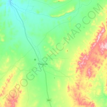
Naam: Topografische kaart Carrieton, hoogte, reliëf.
Gemiddelde hoogte: 481 m
Minimale hoogte: 372 m
Maximale hoogte: 699 m
Andere topografische kaarten
Klik op een kaart om zijn topografie, zijn hoogte en zijn reliëf te bekijken.
Belton
Australia > South Australia > The District Council of Orroroo Carrieton
Belton, The District Council of Orroroo Carrieton, South Australia, 5432, Australia
Gemiddelde hoogte: 512 m
Orroroo
Australia > South Australia > The District Council of Orroroo Carrieton > Orroroo
Orroroo, The District Council of Orroroo Carrieton, South Australia, 5431, Australia
Gemiddelde hoogte: 447 m