
Topografische kaart Broken Bow
Interactieve kaart
Klik op de kaart om de hoogte weer te geven.
Over deze kaart
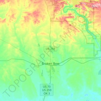
Naam: Topografische kaart Broken Bow, hoogte, reliëf.
Locatie: Broken Bow, McCurtain County, Oklahoma, United States (33.95544 -94.77445 34.15653 -94.70551)
Gemiddelde hoogte: 155 m
Minimale hoogte: 95 m
Maximale hoogte: 304 m
The city sits at the foothills of the Kiamichi Mountains, a subrange of the Ouachita Mountains. the Kiamichi Mountains sit within Le Flore, Pushmataha, and McCurtain counties near the towns of Poteau and Albion. The Kiamichi peaks line up south of the Kiamichi River and reach 2,500 feet (760 m) in elevation. The range is the namesake of Kiamichi Country, the official tourism designation for southeastern Oklahoma.
Andere topografische kaarten
Klik op een kaart om zijn topografie, zijn hoogte en zijn reliëf te bekijken.
Broken Bow Lake
United States > Oklahoma > McCurtain County
Broken Bow Lake, McCurtain County, Oklahoma, United States
Gemiddelde hoogte: 158 m
Candy Mountain
United States > Oklahoma > McCurtain County
Candy Mountain, McCurtain County, Oklahoma, United States
Gemiddelde hoogte: 251 m
Sherwood
United States > Oklahoma > McCurtain County > Sherwood
Sherwood, McCurtain County, Oklahoma, United States
Gemiddelde hoogte: 307 m