
Topografische kaart Dhalai
Interactieve kaart
Klik op de kaart om de hoogte weer te geven.
Over deze kaart
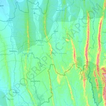
Naam: Topografische kaart Dhalai, hoogte, reliëf.
Locatie: Dhalai, Tripura, India (23.40625 91.74773 24.24118 92.17587)
Gemiddelde hoogte: 138 m
Minimale hoogte: 15 m
Maximale hoogte: 1.066 m
The climate in Setrai, which is about 40 km from Ambassa, displays characteristics that are typical of the hilly and mountainous region. The change in the topographical features, heavy rainfall and altitude of the region causes a change in the climatic conditions in Setrai. The climate and other factors of the terrain and the soil are suitable conditions for horticulture.
Andere topografische kaarten
Klik op een kaart om zijn topografie, zijn hoogte en zijn reliëf te bekijken.
Gachirampara
Gachirampara, Dasda, North Tripura, Tripura, 799271, India
Gemiddelde hoogte: 93 m
Dharmanagar
Dharmanagar, Panisagar, North Tripura, Tripura, 799250, India
Gemiddelde hoogte: 33 m
Kamalpur
India > Tripura > Durga Chowmuhani
Kamalpur, Durga Chowmuhani, Dhalai, Tripura, 799285, India
Gemiddelde hoogte: 47 m
Arundhauti Nagar Children Park
India > Tripura > Dukli > Agartala
Arundhauti Nagar Children Park, Badharghat, Agartala, Dukli, West Tripura, Tripura, 799003, India
Gemiddelde hoogte: 18 m
Sonamura
India > Tripura > Melaghar Urban
Sonamura, Melaghar Urban, Sepahijala, Tripura, India
Gemiddelde hoogte: 21 m
Kailashahar
Kailashahar, Gournagar, Unokoti, Tripura, 799277, India
Gemiddelde hoogte: 33 m
Dumboor Lake
India > Tripura > Raishyabari > Raishyabari
Dumboor Lake, Raishyabari, Dhalai District, Tripura, India
Gemiddelde hoogte: 108 m
Gumti WLS
India > Tripura > Ganganagar
Gumti WLS, Ganganagar, Dhalai, Tripura, India
Gemiddelde hoogte: 109 m