
Topografische kaart Urgos Lake
Interactieve kaart
Klik op de kaart om de hoogte weer te geven.
Over deze kaart
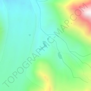
Naam: Topografische kaart Urgos Lake, hoogte, reliëf.
Locatie: Urgos Lake, Lahul, Lahul and Spiti, Himachal Pradesh, India (32.70629 77.34026 32.70910 77.34298)
Gemiddelde hoogte: 4.835 m
Minimale hoogte: 4.566 m
Maximale hoogte: 5.546 m
Andere topografische kaarten
Klik op een kaart om zijn topografie, zijn hoogte en zijn reliëf te bekijken.
Gondhla
India > Himachal Pradesh > Lahul
Gondhla, Lahul, Lahaul and Spiti District, Himachal Pradesh, 175140, India
Gemiddelde hoogte: 3.419 m
Chikka
India > Himachal Pradesh > Lahul
Chikka, Lahul, Lahaul and Spiti District, Himachal Pradesh, India
Gemiddelde hoogte: 4.094 m
Rashil
India > Himachal Pradesh > Lahul > Rape
Rashil, Rape, Lahul, Lahul and Spiti, Himachal Pradesh, India
Gemiddelde hoogte: 3.261 m
Sissu
India > Himachal Pradesh > Lahul
Sissu, Lahul, Lahaul and Spiti District, Himachal Pradesh, India
Gemiddelde hoogte: 3.404 m
Chandratal Lake
India > Himachal Pradesh > Lahul
Chandratal Lake, Lahul, Lahul and Spiti, Himachal Pradesh, India
Gemiddelde hoogte: 4.403 m
Sissu
India > Himachal Pradesh > Lahul > Sissu
Sissu, Lahul, Lahul and Spiti, Himachal Pradesh, India
Gemiddelde hoogte: 4.343 m