
Topografische kaart Arab
Interactieve kaart
Klik op de kaart om de hoogte weer te geven.
Over deze kaart
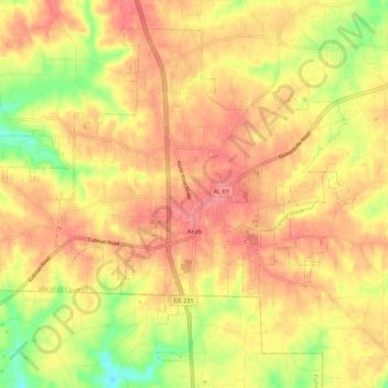
Naam: Topografische kaart Arab, hoogte, reliëf.
Locatie: Arab, Marshall County, Alabama, 35016, United States (34.28777 -86.56015 34.36571 -86.45000)
Gemiddelde hoogte: 314 m
Minimale hoogte: 266 m
Maximale hoogte: 343 m
According to the U.S. Census Bureau, the city has a total area of 13.1 square miles (34.0 km2), of which 14.0 square miles (36.3 km2) is land and 0.12 square miles (0.3 km2), or 1.02%, is water. The town's elevation is 1,124 feet (343 m) above sea level.
Andere topografische kaarten
Klik op een kaart om zijn topografie, zijn hoogte en zijn reliëf te bekijken.
Albertville
United States > Alabama > Marshall County
Albertville, Marshall County, Alabama, 35950, United States
Gemiddelde hoogte: 309 m
Grassy
United States > Alabama > Marshall County
Grassy, Marshall County, Alabama, United States
Gemiddelde hoogte: 309 m