
Topografische kaart Roseville
Interactieve kaart
Klik op de kaart om de hoogte weer te geven.
Over deze kaart
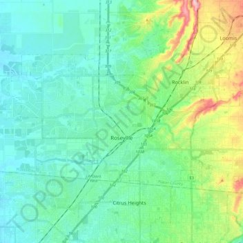
Naam: Topografische kaart Roseville, hoogte, reliëf.
Locatie: Roseville, Placer County, California, United States (38.71635 -121.40025 38.81016 -121.18416)
Gemiddelde hoogte: 61 m
Minimale hoogte: 23 m
Maximale hoogte: 190 m
Roseville has a hot-summer Mediterranean climate that is characterized by cool, wet, usually snowless winters and hot, dry summers (Köppen Csa). The wet season is generally October through April. Because Roseville is east of Sacramento and at a higher elevation, it receives slightly more rainfall. Average daily high temperatures range from 53 °F (12 °C) in January to 94 °F (34 °C) in July. Daily low temperatures range from 39 °F (4 °C) in winter to 61 °F (16 °C) in summer.
Andere topografische kaarten
Klik op een kaart om zijn topografie, zijn hoogte en zijn reliëf te bekijken.
Colfax
United States > California > Placer County
Colfax, Placer County, California, United States
Gemiddelde hoogte: 685 m
Carnelian Bay
United States > California > Placer County
Carnelian Bay, Placer County, California, 96148, United States
Gemiddelde hoogte: 1.977 m
Tahoma
United States > California > Placer County
Tahoma, Placer County, California, 96142, United States
Gemiddelde hoogte: 1.923 m
Lincoln
United States > California > Placer County > Lincoln
Lincoln, Placer County, California, 95648, United States
Gemiddelde hoogte: 60 m
Lake Tahoe
United States > California > Placer County
Lake Tahoe, Placer County, California, United States
Gemiddelde hoogte: 2.077 m
Weimar
United States > California > Placer County
Weimar, Placer County, California, 95736, United States
Gemiddelde hoogte: 662 m
Folsom Lake
United States > California > Placer County > Folsom
Folsom Lake, Folsom, Placer County, California, United States
Gemiddelde hoogte: 223 m
Olympic Valley
United States > California > Placer County
Olympic Valley, Placer County, California, 96146, United States
Gemiddelde hoogte: 2.082 m
Oxbow Reservoir
United States > California > Placer County
Oxbow Reservoir, Placer County, California, United States
Gemiddelde hoogte: 604 m
Lincoln
United States > California > Placer County
Lincoln, Placer County, California, United States
Gemiddelde hoogte: 34 m
Blue Canyon
United States > California > Placer County
Blue Canyon, Placer County, California, 95701, United States
Gemiddelde hoogte: 1.452 m
Auburn
United States > California > Placer County
Auburn, Placer County, California, 95603, United States
Gemiddelde hoogte: 380 m
Foresthill
United States > California > Placer County
Foresthill, Placer County, California, 95631, United States
Gemiddelde hoogte: 749 m
Rocklin
United States > California > Placer County
Rocklin, Placer County, California, United States
Gemiddelde hoogte: 95 m
Applegate
United States > California > Placer County
Applegate, Placer County, California, 95703, United States
Gemiddelde hoogte: 588 m
Gold Run
United States > California > Placer County
Gold Run, Placer County, California, 95717, United States
Gemiddelde hoogte: 930 m
Tahoe City
United States > California > Placer County
Tahoe City, Placer County, California, 96145, United States
Gemiddelde hoogte: 2.005 m