
Topografische kaart Carnelian Bay
Interactieve kaart
Klik op de kaart om de hoogte weer te geven.
Over deze kaart
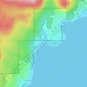
Naam: Topografische kaart Carnelian Bay, hoogte, reliëf.
Gemiddelde hoogte: 1.977 m
Minimale hoogte: 1.894 m
Maximale hoogte: 2.227 m
For statistical purposes, the United States Census Bureau has defined Carnelian Bay as a census-designated place (CDP). The census definition of the area may not precisely correspond to local understanding of the area with the same name. The population was 524 at the 2010 census. The elevation is 6,325 feet (1,928 m).
Andere topografische kaarten
Klik op een kaart om zijn topografie, zijn hoogte en zijn reliëf te bekijken.
Colfax
United States > California > Placer County
Colfax, Placer County, California, United States
Gemiddelde hoogte: 685 m
Tahoma
United States > California > Placer County
Tahoma, Placer County, California, 96142, United States
Gemiddelde hoogte: 1.923 m
Lincoln
United States > California > Placer County > Lincoln
Lincoln, Placer County, California, 95648, United States
Gemiddelde hoogte: 60 m
Lake Tahoe
United States > California > Placer County
Lake Tahoe, Placer County, California, United States
Gemiddelde hoogte: 2.077 m
Weimar
United States > California > Placer County
Weimar, Placer County, California, 95736, United States
Gemiddelde hoogte: 662 m
Folsom Lake
United States > California > Placer County > Folsom
Folsom Lake, Folsom, Placer County, California, United States
Gemiddelde hoogte: 223 m
Olympic Valley
United States > California > Placer County
Olympic Valley, Placer County, California, 96146, United States
Gemiddelde hoogte: 2.082 m
Oxbow Reservoir
United States > California > Placer County
Oxbow Reservoir, Placer County, California, United States
Gemiddelde hoogte: 604 m
Lincoln
United States > California > Placer County
Lincoln, Placer County, California, United States
Gemiddelde hoogte: 34 m
Blue Canyon
United States > California > Placer County
Blue Canyon, Placer County, California, 95701, United States
Gemiddelde hoogte: 1.452 m
Auburn
United States > California > Placer County
Auburn, Placer County, California, 95603, United States
Gemiddelde hoogte: 380 m
Roseville
United States > California > Placer County
Roseville, Placer County, California, United States
Gemiddelde hoogte: 61 m
Foresthill
United States > California > Placer County
Foresthill, Placer County, California, 95631, United States
Gemiddelde hoogte: 749 m
Rocklin
United States > California > Placer County
Rocklin, Placer County, California, United States
Gemiddelde hoogte: 95 m
Applegate
United States > California > Placer County
Applegate, Placer County, California, 95703, United States
Gemiddelde hoogte: 588 m
Gold Run
United States > California > Placer County
Gold Run, Placer County, California, 95717, United States
Gemiddelde hoogte: 930 m
Tahoe City
United States > California > Placer County
Tahoe City, Placer County, California, 96145, United States
Gemiddelde hoogte: 2.005 m