
Topografische kaart Westminster
Interactieve kaart
Klik op de kaart om de hoogte weer te geven.
Over deze kaart
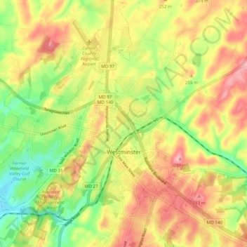
Naam: Topografische kaart Westminster, hoogte, reliëf.
Locatie: Westminster, Carroll County, Maryland, United States (39.54647 -77.04708 39.62053 -76.95920)
Gemiddelde hoogte: 228 m
Minimale hoogte: 161 m
Maximale hoogte: 290 m
Westminster lies in the humid subtropical climate zone bordering on a humid continental climate, with hot and humid summers and cool winters with highly variable seasonal snowfall. Due to its elevation, distance from the Chesapeake Bay and urban heat island, temperatures in Westminster are often considerably lower than in Baltimore, especially at night.
Andere topografische kaarten
Klik op een kaart om zijn topografie, zijn hoogte en zijn reliëf te bekijken.
Gist
United States > Maryland > Carroll County
Gist, Carroll County, Maryland, United States
Gemiddelde hoogte: 203 m
Kimberly Heights
United States > Maryland > Carroll County
Kimberly Heights, Carroll County, Maryland, United States
Gemiddelde hoogte: 209 m
Mount Airy
United States > Maryland > Carroll County
Mount Airy, Carroll County, Maryland, 21771, United States
Gemiddelde hoogte: 221 m
Union Bridge
United States > Maryland > Carroll County
Union Bridge, Carroll County, Maryland, United States
Gemiddelde hoogte: 138 m
Sykesville
United States > Maryland > Carroll County
Sykesville, Carroll County, Maryland, United States
Gemiddelde hoogte: 152 m