
Topografische kaart Kimberly Heights
Interactieve kaart
Klik op de kaart om de hoogte weer te geven.
Over deze kaart
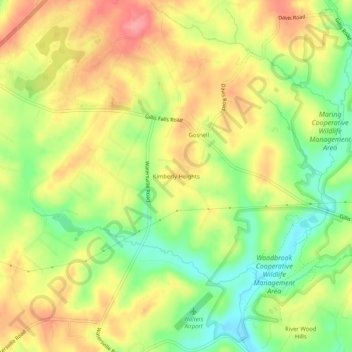
Naam: Topografische kaart Kimberly Heights, hoogte, reliëf.
Locatie: Kimberly Heights, Carroll County, Maryland, United States (39.37733 -77.11998 39.41733 -77.07998)
Gemiddelde hoogte: 209 m
Minimale hoogte: 162 m
Maximale hoogte: 251 m
Andere topografische kaarten
Klik op een kaart om zijn topografie, zijn hoogte en zijn reliëf te bekijken.
Gist
United States > Maryland > Carroll County
Gist, Carroll County, Maryland, United States
Gemiddelde hoogte: 203 m
Mount Airy
United States > Maryland > Carroll County
Mount Airy, Carroll County, Maryland, 21771, United States
Gemiddelde hoogte: 221 m
Union Bridge
United States > Maryland > Carroll County
Union Bridge, Carroll County, Maryland, United States
Gemiddelde hoogte: 138 m
Westminster
United States > Maryland > Carroll County
Westminster, Carroll County, Maryland, United States
Gemiddelde hoogte: 228 m
Sykesville
United States > Maryland > Carroll County
Sykesville, Carroll County, Maryland, United States
Gemiddelde hoogte: 152 m