
Topografische kaart Northfield
Interactieve kaart
Klik op de kaart om de hoogte weer te geven.
Over deze kaart
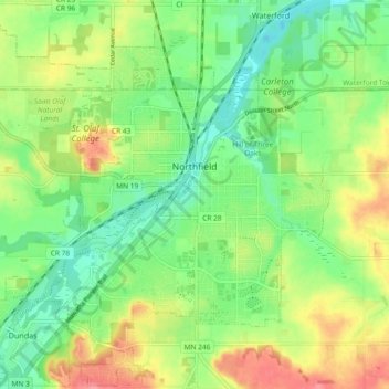
Naam: Topografische kaart Northfield, hoogte, reliëf.
Locatie: Northfield, Rice County, Minnesota, 55057, United States (44.42084 -93.22144 44.48590 -93.12889)
Gemiddelde hoogte: 300 m
Minimale hoogte: 268 m
Maximale hoogte: 347 m
According to the United States Census Bureau, the city has an area of 8.61 square miles (22.30 km2); 8.56 square miles (22.17 km2) is land and 0.05 square miles (0.13 km2) is water. The peak elevation is about 912 feet.
Andere topografische kaarten
Klik op een kaart om zijn topografie, zijn hoogte en zijn reliëf te bekijken.
Dundas
United States > Minnesota > Rice County
Dundas, Rice County, Minnesota, United States
Gemiddelde hoogte: 297 m
Heath Creek
United States > Minnesota > Rice County > Northfield
Heath Creek, Northfield, Rice County, Minnesota, 55057, United States
Gemiddelde hoogte: 292 m
Northfield
United States > Minnesota > Rice County
Northfield, Dundas, Rice County, Minnesota, 55057, United States
Gemiddelde hoogte: 300 m