
Topografische kaart Dundas
Interactieve kaart
Klik op de kaart om de hoogte weer te geven.
Over deze kaart
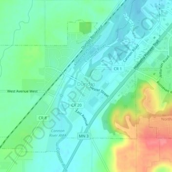
Naam: Topografische kaart Dundas, hoogte, reliëf.
Locatie: Dundas, Rice County, Minnesota, United States (44.41871 -93.22127 44.43951 -93.19062)
Gemiddelde hoogte: 297 m
Minimale hoogte: 276 m
Maximale hoogte: 347 m
According to the United States Census Bureau, the city has a total area of 1.92 square miles (4.97 km2), all land. The Cannon River passes through the center of town. The latitude of Dundas is 44.429N. The longitude is 93.204W. Dundas' elevation is 932 feet above sea level.
Andere topografische kaarten
Klik op een kaart om zijn topografie, zijn hoogte en zijn reliëf te bekijken.
Heath Creek
United States > Minnesota > Rice County > Northfield
Heath Creek, Northfield, Rice County, Minnesota, 55057, United States
Gemiddelde hoogte: 292 m
Northfield
United States > Minnesota > Rice County
Northfield, Dundas, Rice County, Minnesota, 55057, United States
Gemiddelde hoogte: 300 m
Northfield
United States > Minnesota > Rice County
Northfield, Rice County, Minnesota, 55057, United States
Gemiddelde hoogte: 300 m