
Topografische kaart Yushu Tibetan Autonomous Prefecture
Interactieve kaart
Klik op de kaart om de hoogte weer te geven.
Over deze kaart
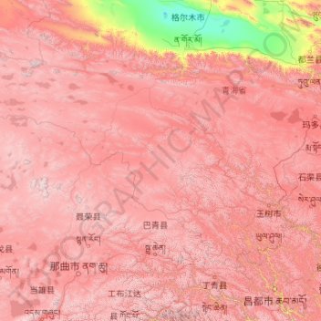
Naam: Topografische kaart Yushu Tibetan Autonomous Prefecture, hoogte, reliëf.
Locatie: Yushu Tibetan Autonomous Prefecture, Qinghai, China (31.60180 89.40222 36.28011 97.75823)
Gemiddelde hoogte: 4.472 m
Minimale hoogte: 2.678 m
Maximale hoogte: 6.537 m
With elevations above 3,600 metres (12,000 ft), the prefecture has a harsh climate, with long, cold winters, and short, rainy, and cool to warm summers. Specifically, in the Köppen system, the prefecture ranges from the alpine variation of the subarctic climate (Köppen Dwc), to a full alpine climate (Köppen EH), to a semi-arid climate (Köppen BSk).[9] Most of the annual precipitation occurs from June to September, when on average, a majority of the days each month has some rainfall. The annual mean temperature in Yushu County, at an elevation of 3,690 metres (12,110 ft), is 3.22 °C (37.8 °F) and in Qumarlêb, in the northeast of the prefecture at 4,190 m (13,750 ft) elevation, −2.13 °C (28.2 °F). Sunshine is generous, ranging from around 2500 hours in the prefecture seat to 2780 hours in Qumarlêb.
Andere topografische kaarten
Klik op een kaart om zijn topografie, zijn hoogte en zijn reliëf te bekijken.
Tanggulashan
Tanggulashan, Golmud, Haixi Mongol and Tibetan Autonomous Prefecture, Qinghai, China
Gemiddelde hoogte: 4.756 m
上赛巴村
China > Qinghai > Chindu County
上赛巴村, Chindu County, Yushu, Qinghai, China
Gemiddelde hoogte: 4.050 m
Golmud City
Golmud City, Haixi Mongol and Tibetan Autonomous Prefecture, Qinghai, 816099, China
Gemiddelde hoogte: 4.324 m
Qumarlêb County
Qumarlêb County, Yushu Tibetan Autonomous Prefecture, Qinghai, China
Gemiddelde hoogte: 4.505 m
Huangnan
China > Qinghai > Tongren City
Huangnan, Tongren City, Huangnan Tibetan Autonomous Prefecture, Qinghai, China
Gemiddelde hoogte: 3.194 m
Golog Tibetan Autonomous Prefecture
China > Qinghai > Gadê County
Golog Tibetan Autonomous Prefecture, Gadê County, Golog Tibetan Autonomous Prefecture, Qinghai, China
Gemiddelde hoogte: 4.340 m
Lamu
China > Qinghai > Hualong Hui Autonomous County
Lamu, Hualong Hui Autonomous County, Haidong, Qinghai, China
Gemiddelde hoogte: 2.256 m
Xireg
China > Qinghai > Ulan County > Xireg
Xireg, Ulan County, Haixi Mongol and Tibetan Autonomous Prefecture, Qinghai, China
Gemiddelde hoogte: 3.248 m
Golog Tibetan Autonomous Prefecture
China > Qinghai > Maqên County > Golog Tibetan Autonomous Prefecture
Golog Tibetan Autonomous Prefecture, Maqên County, Golog Tibetan Autonomous Prefecture, Qinghai, China
Gemiddelde hoogte: 4.148 m
Tanggula Mountains
China > Qinghai > Yanshiping
Tanggula Mountains, Yanshiping, Golmud City, Haixi Mongol and Tibetan Autonomous Prefecture, Qinghai, China
Gemiddelde hoogte: 5.912 m