
Topografische kaart Washington County
Interactieve kaart
Klik op de kaart om de hoogte weer te geven.
Over deze kaart
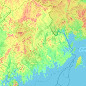
Naam: Topografische kaart Washington County, hoogte, reliëf.
Locatie: Washington County, Maine, United States (44.31693 -68.10502 45.68924 -66.88542)
Gemiddelde hoogte: 74 m
Minimale hoogte: -2 m
Maximale hoogte: 453 m
Andere topografische kaarten
Klik op een kaart om zijn topografie, zijn hoogte en zijn reliëf te bekijken.
Clifford Lake
United States > Maine > Washington County > Greenlaw Chopping Township
Clifford Lake, Greenlaw Chopping Township, Washington County, Maine, United States
Gemiddelde hoogte: 82 m
Burlington
United States > Maine > Penobscot County
Burlington, Penobscot County, Maine, 04417, United States
Gemiddelde hoogte: 108 m
Hodge Hill
United States > Maine > Androscoggin County > Minot
Hodge Hill, Minot, Androscoggin County, Maine, 04258, United States
Gemiddelde hoogte: 136 m
South Portland
United States > Maine > Cumberland County
South Portland, Cumberland County, Maine, 04106, United States
Gemiddelde hoogte: 9 m
Moose River
United States > Maine > Somerset County
Moose River, Somerset County, Maine, United States
Gemiddelde hoogte: 473 m
Milford
United States > Maine > Penobscot County
Milford, Penobscot County, Maine, 04461, United States
Gemiddelde hoogte: 40 m
Marion Island
United States > Maine > Piscataquis County > Lobster Township
Marion Island, Lobster Township, Piscataquis County, Maine, United States
Gemiddelde hoogte: 300 m
Portage
United States > Maine > Aroostook County > Portage Lake
Portage, Portage Lake, Aroostook County, Maine, 04768, United States
Gemiddelde hoogte: 226 m
Battle Island
United States > Maine > Hancock County > Penobscot
Battle Island, Penobscot, Hancock County, Maine, 04476, United States
Gemiddelde hoogte: 53 m
Kittery
United States > Maine > York County
Kittery, York County, Maine, United States
Gemiddelde hoogte: 8 m
Bull Mountain
United States > Maine > Oxford County
Bull Mountain, Oxford County, Maine, United States
Gemiddelde hoogte: 750 m
temp
United States > Maine > York County > Hollis
temp, Hollis, York County, Maine, 04042, United States
Gemiddelde hoogte: 103 m
Bristol
United States > Maine > Lincoln County
Bristol, Lincoln County, Maine, United States
Gemiddelde hoogte: 13 m
York
United States > Maine > York County
York, York County, Maine, United States
Gemiddelde hoogte: 18 m
North Haven Island
United States > Maine > Knox County > North Haven
North Haven Island, North Haven, Knox County, Maine, 04853, United States
Gemiddelde hoogte: 6 m
Upper Chain Lake
United States > Maine > Hancock County
Upper Chain Lake, Hancock County, Maine, United States
Gemiddelde hoogte: 110 m
New Limerick
United States > Maine > Aroostook County
New Limerick, Aroostook County, Maine, 04761, United States
Gemiddelde hoogte: 155 m
Masardis
United States > Maine > Aroostook County
Masardis, Aroostook County, Maine, United States
Gemiddelde hoogte: 199 m
Bar Harbor
United States > Maine > Hancock County
Bar Harbor, Hancock County, Maine, 04609, United States
Gemiddelde hoogte: 33 m
Penobscot Bay
United States > Maine > Knox County > North Haven
Penobscot Bay, North Haven, Knox County, Maine, United States
Gemiddelde hoogte: 0 m
Sebascodegan Island
United States > Maine > Cumberland County > Harpswell
Sebascodegan Island, Harpswell, Cumberland County, Maine, 04079, United States
Gemiddelde hoogte: 8 m
Little Sebago Lake
United States > Maine > Cumberland County > Gray
Little Sebago Lake, Gray, Cumberland County, Maine, 04039, United States
Gemiddelde hoogte: 108 m
Pownal
United States > Maine > Cumberland County
Pownal, Cumberland County, Maine, 04069, United States
Gemiddelde hoogte: 54 m
Cumberland
United States > Maine > Cumberland County
Cumberland, Cumberland County, Maine, United States
Gemiddelde hoogte: 51 m
Newfield
United States > Maine > York County
Newfield, York County, Maine, 04095, United States
Gemiddelde hoogte: 155 m
Presque Isle
United States > Maine > Aroostook County
Presque Isle, Aroostook County, Maine, 04769, United States
Gemiddelde hoogte: 180 m
Harpswell
United States > Maine > Cumberland County
Harpswell, Cumberland County, Maine, 04079, United States
Gemiddelde hoogte: 5 m
Sabattus
United States > Maine > Androscoggin County
Sabattus, Androscoggin County, Maine, 04280, United States
Gemiddelde hoogte: 83 m
Woolwich
United States > Maine > Sagadahoc County
Woolwich, Sagadahoc County, Maine, 04579, United States
Gemiddelde hoogte: 21 m
Dedham
United States > Maine > Hancock County
Dedham, Hancock County, Maine, 04429, United States
Gemiddelde hoogte: 112 m
Glen Cove
United States > Maine > Knox County > Rockport
Glen Cove, Rockport, Knox County, Maine, 04841, United States
Gemiddelde hoogte: 30 m
Belgrade
United States > Maine > Kennebec County
Belgrade, Kennebec County, Maine, United States
Gemiddelde hoogte: 104 m
Islesboro
United States > Maine > Waldo County
Islesboro, Waldo County, Maine, 04848, United States
Gemiddelde hoogte: 18 m
Owls Head
United States > Maine > Knox County
Owls Head, Knox County, Maine, 04854, United States
Gemiddelde hoogte: 4 m
Appalachian National Scenic Trail
United States > Maine > Franklin County > Carrabassett Valley
Appalachian National Scenic Trail, Carrabassett Valley, Franklin County, Maine, United States
Gemiddelde hoogte: 419 m
Greenwood
United States > Maine > Oxford County
Greenwood, Oxford County, Maine, 04255, United States
Gemiddelde hoogte: 295 m
Ellsworth
United States > Maine > Hancock County
Ellsworth, Hancock County, Maine, United States
Gemiddelde hoogte: 53 m
Augusta
United States > Maine > Kennebec County
Augusta, Kennebec County, Maine, 04330, United States
Gemiddelde hoogte: 75 m
East Branch Big Musquash Stream
United States > Maine > Washington County > Talmadge
East Branch Big Musquash Stream, Talmadge, Washington County, Maine, United States
Gemiddelde hoogte: 112 m
Belfast
United States > Maine > Waldo County
Belfast, Waldo County, Maine, 04915, United States
Gemiddelde hoogte: 52 m
Brunswick
United States > Maine > Cumberland County
Brunswick, Cumberland County, Maine, 04011, United States
Gemiddelde hoogte: 24 m
Millinocket
United States > Maine > Penobscot County
Millinocket, Penobscot County, Maine, 04462, United States
Gemiddelde hoogte: 140 m
Crescent Beach
United States > Maine > Cumberland County > Cape Elizabeth
Crescent Beach, Cape Elizabeth, Cumberland County, Maine, 04107, United States
Gemiddelde hoogte: 6 m
Island Falls
United States > Maine > Aroostook County
Island Falls, Aroostook County, Maine, 04747, United States
Gemiddelde hoogte: 159 m
Bates-Morse Mountain Conservation Area
United States > Maine > Sagadahoc County > Phippsburg
Bates-Morse Mountain Conservation Area, Popham Road, Phippsburg, Sagadahoc County, Maine, 04565, United States
Gemiddelde hoogte: 9 m
Lakeville
United States > Maine > Penobscot County
Lakeville, Penobscot County, Maine, United States
Gemiddelde hoogte: 132 m
Prentiss Township
United States > Maine > Penobscot County
Prentiss Township, Penobscot County, Maine, United States
Gemiddelde hoogte: 153 m
Deblois
United States > Maine > Washington County
Deblois, Washington County, Maine, 04622, United States
Gemiddelde hoogte: 62 m