
Topografische kaart Chugchillan
Interactieve kaart
Klik op de kaart om de hoogte weer te geven.
Over deze kaart
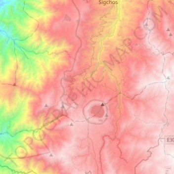
Naam: Topografische kaart Chugchillan, hoogte, reliëf.
Locatie: Chugchillan, Sigchos, Cotopaxi, 00000, Ecuador (-0.89499 -79.11735 -0.75441 -78.87170)
Gemiddelde hoogte: 3.158 m
Minimale hoogte: 1.188 m
Maximale hoogte: 4.280 m
Andere topografische kaarten
Klik op een kaart om zijn topografie, zijn hoogte en zijn reliëf te bekijken.
Quilotoa
Ecuador > Cotopaxi > Sigchos > Chugchillan
Quilotoa, Chugchillan, Sigchos, Cotopaxi, 050456, Ecuador
Gemiddelde hoogte: 3.553 m
Laguna Quilotoa
Ecuador > Cotopaxi > Sigchos > Chugchillan
Laguna Quilotoa, Chugchillan, Sigchos, Cotopaxi, Ecuador
Gemiddelde hoogte: 3.636 m