
Topografische kaart Quilotoa
Interactieve kaart
Klik op de kaart om de hoogte weer te geven.
Over deze kaart
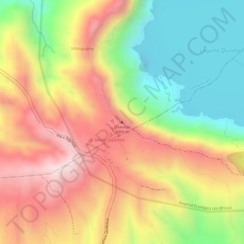
Naam: Topografische kaart Quilotoa, hoogte, reliëf.
Locatie: Quilotoa, Chugchillan, Sigchos, Cotopaxi, 050456, Ecuador (-0.84920 -78.89713 -0.84910 -78.89703)
Gemiddelde hoogte: 3.553 m
Minimale hoogte: 3.326 m
Maximale hoogte: 3.827 m
Andere topografische kaarten
Klik op een kaart om zijn topografie, zijn hoogte en zijn reliëf te bekijken.
Chugchillan
Ecuador > Cotopaxi > Sigchos > Chugchillan
Chugchillan, Sigchos, Cotopaxi, 00000, Ecuador
Gemiddelde hoogte: 3.158 m
Laguna Quilotoa
Ecuador > Cotopaxi > Sigchos > Chugchillan
Laguna Quilotoa, Chugchillan, Sigchos, Cotopaxi, Ecuador
Gemiddelde hoogte: 3.636 m