
Topografische kaart Everett
Klik op de kaart om de hoogte weer te geven.
Over deze kaart
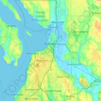
Naam: Topografische kaart Everett, hoogte, reliëf.
Locatie: Everett, Snohomish County, Washington, United States (47.87818 -122.29319 48.03609 -121.79398)
Gemiddelde hoogte: 66 m
Minimale hoogte: -4 m
Maximale hoogte: 421 m
Andere topografische kaarten
Klik op een kaart om zijn topografie, zijn hoogte en zijn reliëf te bekijken.
Glacier Peak
United States > Washington > Snohomish County
Despite its elevation of 10,541 feet (3,213 m), Glacier Peak is a small stratovolcano. Its relatively high summit is a consequence of its location atop a high ridge, but its volcanic portion extends only 1,600–3,200 feet (500–1,000 m) above the underlying ridge. Another Cascade Arc volcano with similar…
Gemiddelde hoogte: 2.656 m
Mill Creek
United States > Washington > Snohomish County > Mill Creek > Mill Creek
Gemiddelde hoogte: 129 m
Whitehorse Mountain
United States > Washington > Snohomish County
Whitehorse Mountain is a peak near the western edge of the North Cascades in Washington state. It is located just southwest of the Sauk River Valley town of Darrington, near the northern boundary of Boulder River Wilderness in Mount Baker-Snoqualmie National Forest. While not of particularly high absolute…
Gemiddelde hoogte: 1.430 m
Bridal Veil Falls-Lower East Cascade
United States > Washington > Snohomish County
Gemiddelde hoogte: 621 m