
Topografische kaart Hat Island
Klik op de kaart om de hoogte weer te geven.
Over deze kaart
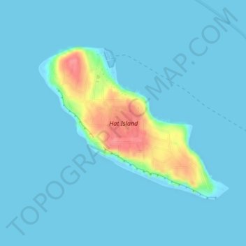
Naam: Topografische kaart Hat Island, hoogte, reliëf.
Locatie: Hat Island, Snohomish County, Washington, United States (48.00465 -122.33509 48.02167 -122.30296)
Gemiddelde hoogte: 9 m
Minimale hoogte: -1 m
Maximale hoogte: 80 m
Andere topografische kaarten
Klik op een kaart om zijn topografie, zijn hoogte en zijn reliëf te bekijken.
Marysville
United States > Washington > Snohomish County
The city's topography varies from the low-lying downtown, located along the banks of Ebey Slough 5 feet (1.5 m) above sea level, rising to 160 feet (49 m) near Smokey Point and over 465 feet (142 m) in the eastern highlands. Marysville sits in the watershed of two major creeks, Quilceda Creek and Allen Creek,…
Gemiddelde hoogte: 72 m
Monroe
United States > Washington > Snohomish County
The city lies at the eastern end of the Snohomish River floodplain, with elevations that range from 40 to 210 feet (12 to 64 m). The south and east edges of the city along the Skykomish River are within a 100-year flood hazard zone and also include habitats for migratory birds and game animals. The residential…
Gemiddelde hoogte: 49 m
Arlington
United States > Washington > Snohomish County
The city lies on a glacial terrace formed during the Pleistocene epoch by the recession of the Cordilleran Ice Sheet. Arlington covers a series of hills that sit at an elevation of 100 to 200 feet (30 to 61 m) above sea level. Downtown Arlington is situated on a bluff above the confluence of the Stillaguamish…
Gemiddelde hoogte: 60 m
Mountlake Terrace
United States > Washington > Snohomish County
The city sits on a plateau that is elevated from the surrounding landscape, with views of the Olympic and Cascade mountains. The Mountlake Terrace's elevation ranges from 263 to 528 feet (80 to 161 m) above sea level, with an average altitude of 440 feet (130 m). The southwestern portion of the city includes…
Gemiddelde hoogte: 121 m
Stanwood
United States > Washington > Snohomish County
The city is located at the mouth of the Stillaguamish River, where it flows into Port Susan, an arm of the Puget Sound, and Skagit Bay, the mouth of the Skagit River. To the west is Davis Slough, which separates Stanwood from Camano Island and forms the border between Snohomish and Island counties. Elevations…
Gemiddelde hoogte: 20 m
Glacier Peak
United States > Washington > Snohomish County
Despite its elevation of 10,541 feet (3,213 m), Glacier Peak is a small stratovolcano. Its relatively high summit is a consequence of its location atop a high ridge, but its volcanic portion extends only 1,600–3,200 feet (500–1,000 m) above the underlying ridge. Another Cascade Arc volcano with similar…
Gemiddelde hoogte: 2.656 m
Mountlake Terrace
United States > Washington > Snohomish County
The city sits on a plateau that is elevated from the surrounding landscape, with views of the Olympic and Cascade mountains. The Mountlake Terrace's elevation ranges from 263 to 528 feet (80 to 161 m) above sea level, with an average altitude of 440 feet (130 m). The southwestern portion of the city includes…
Gemiddelde hoogte: 121 m
Stanwood
United States > Washington > Snohomish County
The city is located at the mouth of the Stillaguamish River, where it flows into Port Susan, an arm of the Puget Sound, and Skagit Bay, the mouth of the Skagit River. To the west is Davis Slough, which separates Stanwood from Camano Island and forms the border between Snohomish and Island counties. Elevations…
Gemiddelde hoogte: 20 m
Glacier Peak
United States > Washington > Snohomish County
Despite its elevation of 10,541 feet (3,213 m), Glacier Peak is a small stratovolcano. Its relatively high summit is a consequence of its location atop a high ridge, but its volcanic portion extends only 1,600–3,200 feet (500–1,000 m) above the underlying ridge. Another Cascade Arc volcano with similar…
Gemiddelde hoogte: 2.656 m
Mill Creek
United States > Washington > Snohomish County > Mill Creek > Mill Creek
Gemiddelde hoogte: 129 m
Whitehorse Mountain
United States > Washington > Snohomish County
Whitehorse Mountain is a peak near the western edge of the North Cascades in Washington state. It is located just southwest of the Sauk River Valley town of Darrington, near the northern boundary of Boulder River Wilderness in Mount Baker-Snoqualmie National Forest. While not of particularly high absolute…
Gemiddelde hoogte: 1.430 m
Arlington
United States > Washington > Snohomish County
The city lies on a glacial terrace formed during the Pleistocene epoch by the recession of the Cordilleran Ice Sheet. Arlington covers a series of hills that sit at an elevation of 100 to 200 feet (30 to 61 m) above sea level. Downtown Arlington is situated on a bluff above the confluence of the Stillaguamish…
Gemiddelde hoogte: 60 m
Gold Bar
United States > Washington > Snohomish County
Gold Bar is known as a white-water rafting destination for those seeking to float the Skykomish River. One of the most popular low elevation hikes in the metro Seattle area, the trail to Wallace Falls, is located on the north margin of the city. More than 160,000 people visit Wallace Falls State Park annually.
Gemiddelde hoogte: 67 m
Marysville
United States > Washington > Snohomish County
The city's topography varies from the low-lying downtown, located along the banks of Ebey Slough 5 feet (1.5 m) above sea level, rising to 160 feet (49 m) near Smokey Point and over 465 feet (142 m) in the eastern highlands. Marysville sits in the watershed of two major creeks, Quilceda Creek and Allen Creek,…
Gemiddelde hoogte: 72 m
Bridal Veil Falls-Lower East Cascade
United States > Washington > Snohomish County
Gemiddelde hoogte: 621 m