
Topografische kaart Boerne
Klik op de kaart om de hoogte weer te geven.
Over deze kaart
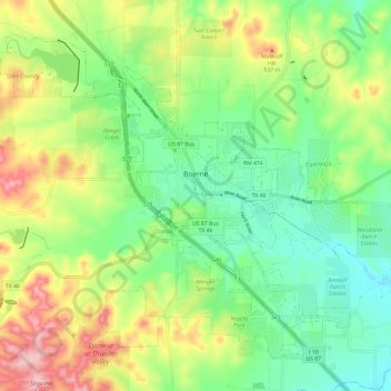
Naam: Topografische kaart Boerne, hoogte, reliëf.
Locatie: Boerne, Kendall County, Texas, United States (29.74552 -98.80201 29.83211 -98.68245)
Gemiddelde hoogte: 465 m
Minimale hoogte: 398 m
Maximale hoogte: 576 m
Andere topografische kaarten
Klik op een kaart om zijn topografie, zijn hoogte en zijn reliëf te bekijken.
Bergheim
United States > Texas > Kendall County
Bergheim is an unincorporated community in eastern Kendall County, Texas, United States known for its German-Texan culture and heritage. It lies along State Highway 46 east of the city of Boerne, the county seat of Kendall County. Its elevation is 1,437 feet (438 m). Although Bergheim is unincorporated, it has…
Gemiddelde hoogte: 419 m