
Topografische kaart Bergheim
Interactieve kaart
Klik op de kaart om de hoogte weer te geven.
Over deze kaart
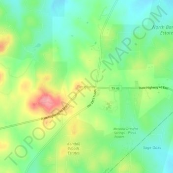
Naam: Topografische kaart Bergheim, hoogte, reliëf.
Locatie: Bergheim, Kendall County, Texas, 78004, United States (29.80744 -98.59530 29.84744 -98.55530)
Gemiddelde hoogte: 419 m
Minimale hoogte: 380 m
Maximale hoogte: 481 m
Bergheim is an unincorporated community in eastern Kendall County, Texas, United States known for its German-Texan culture and heritage. It lies along State Highway 46 east of the city of Boerne, the county seat of Kendall County. Its elevation is 1,437 feet (438 m). Although Bergheim is unincorporated, it has a post office, with the ZIP code of 78004; the ZCTA for ZIP Code 78004, consisting mostly of rural land, had a population of 1,183 at the 2010 census. The community is part of the San Antonio metropolitan statistical area. Bergheim is still a predominantly a ranching and agricultural community.
Andere topografische kaarten
Klik op een kaart om zijn topografie, zijn hoogte en zijn reliëf te bekijken.
Boerne
United States > Texas > Kendall County
Boerne, Kendall County, Texas, United States
Gemiddelde hoogte: 465 m
Walnut Grove
United States > Texas > Kendall County
Walnut Grove, Kendall County, Texas, United States
Gemiddelde hoogte: 455 m
Kreutzberg
United States > Texas > Kendall County
Kreutzberg, Kendall County, Texas, United States
Gemiddelde hoogte: 426 m
Boerne
United States > Texas > Kendall County
Boerne, Kendall County, Texas, United States
Gemiddelde hoogte: 465 m
Waring
United States > Texas > Kendall County
Waring, Kendall County, Texas, 78074, United States
Gemiddelde hoogte: 425 m
Comfort
United States > Texas > Kendall County
Comfort, Kendall County, Texas, 70813, United States
Gemiddelde hoogte: 457 m
Nelson City
United States > Texas > Kendall County
Nelson City, Kendall County, Texas, United States
Gemiddelde hoogte: 485 m