
Topografische kaart Angel Glacier
Interactieve kaart
Klik op de kaart om de hoogte weer te geven.
Over deze kaart
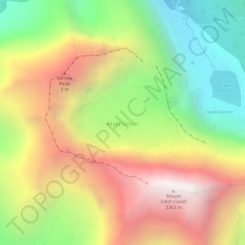
Naam: Topografische kaart Angel Glacier, hoogte, reliëf.
Gemiddelde hoogte: 2.504 m
Minimale hoogte: 1.729 m
Maximale hoogte: 3.360 m
Andere topografische kaarten
Klik op een kaart om zijn topografie, zijn hoogte en zijn reliëf te bekijken.
Roche Noir
Canada > Alberta > Improvement District No. 12
Roche Noir, Improvement District No. 12, Alberta, Canada
Gemiddelde hoogte: 2.306 m
Maligne Lake
Canada > Alberta > Improvement District No. 12
Maligne Lake, Improvement District No. 12, Alberta, Canada
Gemiddelde hoogte: 2.125 m
Athabasca Glacier
Canada > Alberta > Improvement District No. 12
Athabasca Glacier, Improvement District No. 12, Alberta, Canada
Gemiddelde hoogte: 2.483 m