
Topografische kaart Maligne Lake
Interactieve kaart
Klik op de kaart om de hoogte weer te geven.
Over deze kaart
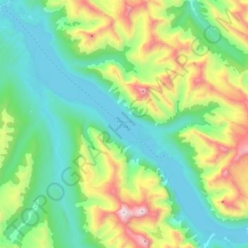
Naam: Topografische kaart Maligne Lake, hoogte, reliëf.
Locatie: Maligne Lake, Improvement District No. 12, Alberta, Canada (52.59363 -117.64318 52.72898 -117.40968)
Gemiddelde hoogte: 2.125 m
Minimale hoogte: 1.670 m
Maximale hoogte: 3.242 m
Wildlife is surprisingly abundant along this high altitude oligotrophic lake. Grizzly bear, black bear, mule deer, caribou, wolves, moose, and mountain sheep are some of the larger mammals that frequent the lake area during the summer season. Bald eagles, golden eagles and osprey also frequent the area and live off the fish populations.
Andere topografische kaarten
Klik op een kaart om zijn topografie, zijn hoogte en zijn reliëf te bekijken.
Roche Noir
Canada > Alberta > Improvement District No. 12
Roche Noir, Improvement District No. 12, Alberta, Canada
Gemiddelde hoogte: 2.306 m
Athabasca Glacier
Canada > Alberta > Improvement District No. 12
Athabasca Glacier, Improvement District No. 12, Alberta, Canada
Gemiddelde hoogte: 2.483 m
Angel Glacier
Canada > Alberta > Improvement District No. 12
Angel Glacier, Improvement District No. 12, Alberta, Canada
Gemiddelde hoogte: 2.504 m