
Topografische kaart Rimbuhl
Interactieve kaart
Klik op de kaart om de hoogte weer te geven.
Over deze kaart
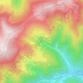
Naam: Topografische kaart Rimbuhl, hoogte, reliëf.
Gemiddelde hoogte: 911 m
Minimale hoogte: 431 m
Maximale hoogte: 1.281 m
Andere topografische kaarten
Klik op een kaart om zijn topografie, zijn hoogte en zijn reliëf te bekijken.
Petit Ballon
France > Grand Est > Haut-Rhin > Linthal
Petit Ballon, Linthal, Thann-Guebwiller, Haut-Rhin, Grand Est, France métropolitaine, 68610, France
Gemiddelde hoogte: 1.050 m
Gustermatt
France > Grand Est > Haut-Rhin > Linthal
Gustermatt, Linthal, Thann-Guebwiller, Haut-Rhin, Grand Est, France métropolitaine, 68610, France
Gemiddelde hoogte: 1.052 m