
Topografische kaart Petit Ballon
Interactieve kaart
Klik op de kaart om de hoogte weer te geven.
Over deze kaart
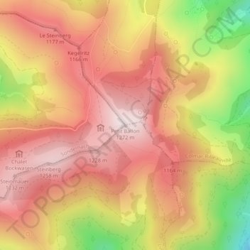
Naam: Topografische kaart Petit Ballon, hoogte, reliëf.
Gemiddelde hoogte: 1.050 m
Minimale hoogte: 676 m
Maximale hoogte: 1.266 m
Le Petit Ballon (Kahler Wasen ou Kleiner Belchen en allemand) est un sommet secondaire du massif des Vosges situé dans le département du Haut-Rhin (Grand Est). Il culmine à 1 272 mètres d'altitude. Son sommet donne un point de vue panoramique, marqué par une statue de la Vierge et une antenne-relais radio. La route ne permet pas d'accéder directement au sommet mais seulement au col à 1 163 m d'altitude.
Andere topografische kaarten
Klik op een kaart om zijn topografie, zijn hoogte en zijn reliëf te bekijken.
Gustermatt
France > Grand Est > Haut-Rhin > Linthal
Gustermatt, Linthal, Thann-Guebwiller, Haut-Rhin, Grand Est, France métropolitaine, 68610, France
Gemiddelde hoogte: 1.052 m