
Doe een donatie
Rust jezelf uit voor je volgende avontuur:
Als Amazon-partner verdient deze site een commissie op in aanmerking komende aankopen, zonder extra kosten voor jou.
Topografische kaart Cle Elum
Klik op de kaart om de hoogte weer te geven.
Doe een donatie
Rust jezelf uit voor je volgende avontuur:
Als Amazon-partner verdient deze site een commissie op in aanmerking komende aankopen, zonder extra kosten voor jou.
Cle Elum
Cle Elum was originally inhabited by the Kittitas band of the Yakama tribe. The tribe fished salmon, steelhead, and trout from the Yakima River. The Salmon la Sac trails in the northern area of the region were created by the Kittitas people and were used as layovers for journeys into the higher altitudes of the Cascade Range. In 1855, after the arrival of Catholic missionaries, and the passing through of settlers and coal miners on their way to the Puget Sound, a treaty resulted in the Yakamas ceding most of their land for a reservation in the lower Yakima Valley and guaranteed access to fish, including what would later be incorporated as Cle Elum. By 1859, the Kittitas had been forced to relocate to the Yakama Indian Reservation.
Doe een donatie
Rust jezelf uit voor je volgende avontuur:
Als Amazon-partner verdient deze site een commissie op in aanmerking komende aankopen, zonder extra kosten voor jou.
Over deze kaart
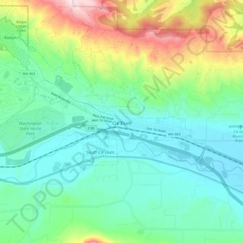
Naam: Topografische kaart Cle Elum, hoogte, reliëf.
Locatie: Cle Elum, Kittitas County, Washington, United States (47.18434 -121.01610 47.20680 -120.90000)
Gemiddelde hoogte: 696 m
Minimale hoogte: 561 m
Maximale hoogte: 1.058 m
Doe een donatie
Rust jezelf uit voor je volgende avontuur:
Als Amazon-partner verdient deze site een commissie op in aanmerking komende aankopen, zonder extra kosten voor jou.
Andere topografische kaarten
Klik op een kaart om zijn topografie, zijn hoogte en zijn reliëf te bekijken.
Cathedral Rock
United States > Washington > Kittitas County
Cathedral Rock is an intrusive andesite volcanic complex. The Alpine Lakes Wilderness features some of the most rugged topography in the Cascade Range with craggy peaks and ridges, deep glacial valleys, and granite walls spotted with over 700 mountain lakes. Geological events occurring many years ago created…
Gemiddelde hoogte: 1.547 m
Doe een donatie
Rust jezelf uit voor je volgende avontuur:
Als Amazon-partner verdient deze site een commissie op in aanmerking komende aankopen, zonder extra kosten voor jou.
Cathedral Rock
United States > Washington > Kittitas County
Cathedral Rock is an intrusive andesite volcanic complex. The Alpine Lakes Wilderness features some of the most rugged topography in the Cascade Range with craggy peaks and ridges, deep glacial valleys, and granite walls spotted with over 700 mountain lakes. Geological events occurring many years ago created…
Gemiddelde hoogte: 1.547 m