
Doe een donatie
Rust jezelf uit voor je volgende avontuur:
Als Amazon-partner verdient deze site een commissie op in aanmerking komende aankopen, zonder extra kosten voor jou.
Topografische kaart Teanaway
Klik op de kaart om de hoogte weer te geven.
Doe een donatie
Rust jezelf uit voor je volgende avontuur:
Als Amazon-partner verdient deze site een commissie op in aanmerking komende aankopen, zonder extra kosten voor jou.
Over deze kaart
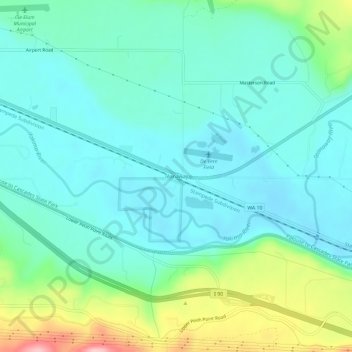
Naam: Topografische kaart Teanaway, hoogte, reliëf.
Gemiddelde hoogte: 592 m
Minimale hoogte: 550 m
Maximale hoogte: 728 m
Doe een donatie
Rust jezelf uit voor je volgende avontuur:
Als Amazon-partner verdient deze site een commissie op in aanmerking komende aankopen, zonder extra kosten voor jou.
Andere topografische kaarten
Klik op een kaart om zijn topografie, zijn hoogte en zijn reliëf te bekijken.
Cle Elum
United States > Washington > Kittitas County
Cle Elum was originally inhabited by the Kittitas band of the Yakama tribe. The tribe fished salmon, steelhead, and trout from the Yakima River. The Salmon la Sac trails in the northern area of the region were created by the Kittitas people and were used as layovers for journeys into the higher altitudes of…
Gemiddelde hoogte: 696 m
Doe een donatie
Rust jezelf uit voor je volgende avontuur:
Als Amazon-partner verdient deze site een commissie op in aanmerking komende aankopen, zonder extra kosten voor jou.
Snoqualmie Pass
United States > Washington > Kittitas County
Due to its elevation, Snoqualmie Pass experiences significantly lower temperatures than Seattle, and receives much more precipitation, much of it being snow. Snoqualmie Pass has a humid continental climate (Koppen: Dsb bordering Csb) with cold, very wet and snowy winters, and mild to warm, relatively dry…
Gemiddelde hoogte: 955 m
Thorp
United States > Washington > Kittitas County
The town of Thorp is 100 miles (160 km) east of Seattle, 8 miles (13 km) northwest of Ellensburg, and 17 miles (27 km) southeast of Cle Elum. It is located at the narrow west end of the Kittitas Valley, where high elevation forests of the Cascade Range give way to cattle ranches surrounded by farmlands noted…
Gemiddelde hoogte: 521 m
Cle Elum
United States > Washington > Kittitas County
Cle Elum was originally inhabited by the Kittitas band of the Yakama tribe. The tribe fished salmon, steelhead, and trout from the Yakima River. The Salmon la Sac trails in the northern area of the region were created by the Kittitas people and were used as layovers for journeys into the higher altitudes of…
Gemiddelde hoogte: 696 m
Doe een donatie
Rust jezelf uit voor je volgende avontuur:
Als Amazon-partner verdient deze site een commissie op in aanmerking komende aankopen, zonder extra kosten voor jou.
Snoqualmie Pass
United States > Washington > Kittitas County
Due to its elevation, Snoqualmie Pass experiences significantly lower temperatures than Seattle, and receives much more precipitation, much of it being snow. Snoqualmie Pass has a humid continental climate (Koppen: Dsb bordering Csb) with cold, very wet and snowy winters, and mild to warm, relatively dry…
Gemiddelde hoogte: 955 m
Cle Elum
United States > Washington > Kittitas County
Cle Elum has a humid continental climate, Köppen subtype Dsb. The elevation is 1909 feet and temperatures are cooler than areas to the east. The coldest month is December, a trait common in the Pacific Northwest. But hot temperatures still occur, and not just in summer: on March 18, 1968, the temperature…
Gemiddelde hoogte: 696 m
Doe een donatie
Rust jezelf uit voor je volgende avontuur:
Als Amazon-partner verdient deze site een commissie op in aanmerking komende aankopen, zonder extra kosten voor jou.
Doe een donatie
Rust jezelf uit voor je volgende avontuur:
Als Amazon-partner verdient deze site een commissie op in aanmerking komende aankopen, zonder extra kosten voor jou.