
Topografische kaart Wilkes County
Interactieve kaart
Klik op de kaart om de hoogte weer te geven.
Over deze kaart
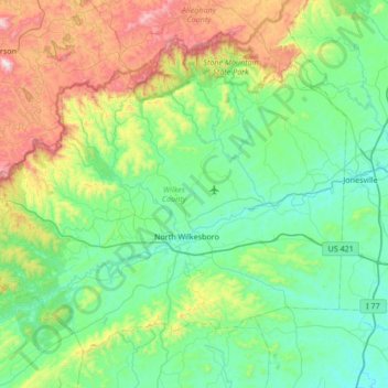
Naam: Topografische kaart Wilkes County, hoogte, reliëf.
Locatie: Wilkes County, North Carolina, United States of America (35.99693 -81.54546 36.44254 -80.87475)
Gemiddelde hoogte: 513 m
Minimale hoogte: 250 m
Maximale hoogte: 1.386 m
Wilkes County is located on the eastern slope of the Blue Ridge Mountains, a part of the Appalachian Mountains chain. The county's elevation ranges from 900 feet (375 meters) in the east to over 4,000 feet (1,219 meters) in the west. The Blue Ridge Mountains run from the southwest to the northeast, and dominate the county's western and northern horizons. Tomkins Knob, the highest point in the county, rises to 4,079 feet (1243 meters). The Blue Ridge Parkway runs along the crest of the Blue Ridge on the county's northern and western borders. The foothills and valleys of the Blue Ridge form most of the county's midsection, with some elevations exceeding 2,000 feet (610 meters). Stone Mountain State Park, located in the foothills of northern Wilkes County, is one of the most popular state parks in North Carolina, and is noted for its excellent rock climbing and trout fishing. The Brushy Mountains, an isolated spur of the Blue Ridge, form the county's southern border. Wilkes County's terrain gradually becomes more level and less hilly as one moves to the east; the far eastern section of the county lies within the Piedmont region of North Carolina. The largest river in Wilkes is the Yadkin River, which flows through the central part of the county. The county's three other major streams, all of which flow into the Yadkin, are the Reddies River, Roaring River, and Mulberry Creek. Following the devastating floods of 1916 and 1940, the US Army's Corps of Engineers constructed the W. Kerr Scott Dam and Reservoir on the Yadkin River four miles west of Wilkesboro. Opened in 1962, the dam created a lake with a shoreline of 56 miles. The lake is used for boating, swimming, fishing, and waterskiing; it is especially noted for its excellent bass fishing. The W. Kerr Scott lake is the largest body of water in Wilkes.
Andere topografische kaarten
Klik op een kaart om zijn topografie, zijn hoogte en zijn reliëf te bekijken.
Raleigh
United States of America > North Carolina > Raleigh
Raleigh, Wake County, North Carolina, 27603-1300, United States of America
Gemiddelde hoogte: 103 m
Kitty Hawk
United States of America > North Carolina > Kitty Hawk
Kitty Hawk, Dare County, North Carolina, United States of America
Gemiddelde hoogte: 2 m
Bethlehem
United States of America > North Carolina > Bethlehem
Bethlehem, Alexander County, North Carolina, United States of America
Gemiddelde hoogte: 315 m
Running Creek
United States of America > North Carolina
Running Creek, Stanly County, North Carolina, United States of America
Gemiddelde hoogte: 189 m
Iredell County
United States of America > North Carolina
Iredell County, North Carolina, United States of America
Gemiddelde hoogte: 276 m
Neuse Crossroads
United States of America > North Carolina > Raleigh > Neuse Crossroads
Neuse Crossroads, Raleigh, Wake County, North Carolina, 27616, United States of America
Gemiddelde hoogte: 75 m
Lake Haven
United States of America > North Carolina > Lake Haven
Lake Haven, Mint Hill, Mecklenburg County, North Carolina, 28227, United States of America
Gemiddelde hoogte: 224 m
Temora Lake Estates
United States of America > North Carolina > Temora Lake Estates
Temora Lake Estates, Forsyth County, North Carolina, 27109, United States of America
Gemiddelde hoogte: 265 m
University Estates
United States of America > North Carolina > Durham > University Estates
University Estates, Durham, Durham County, North Carolina, 27705, United States of America
Gemiddelde hoogte: 131 m
Piney Plains
United States of America > North Carolina > Cary > Piney Plains
Piney Plains, Cary, Wake County, North Carolina, 27518, United States of America
Gemiddelde hoogte: 129 m
Arthurs Creek
United States of America > North Carolina
Arthurs Creek, Northampton County, North Carolina, 27831, United States of America
Gemiddelde hoogte: 35 m
Pheasant Creek
United States of America > North Carolina
Pheasant Creek, Surry County, North Carolina, United States of America
Gemiddelde hoogte: 326 m
Cedar Hill
United States of America > North Carolina > Cedar Hill
Cedar Hill, Surry County, North Carolina, United States of America
Gemiddelde hoogte: 298 m
Barkers Creek
United States of America > North Carolina
Barkers Creek, Forsyth County, North Carolina, 27050, United States of America
Gemiddelde hoogte: 301 m
Mount Pilgrim
United States of America > North Carolina > Mount Pilgrim
Mount Pilgrim, Martin County, North Carolina, United States of America
Gemiddelde hoogte: 25 m
Cape Colony
United States of America > North Carolina > Cape Colony
Cape Colony, Chowan County, North Carolina, United States of America
Gemiddelde hoogte: 2 m
Riddles Creek
United States of America > North Carolina
Riddles Creek, Rutherford County, North Carolina, 28114, United States of America
Gemiddelde hoogte: 259 m
Lake McKenzie
United States of America > North Carolina > Foxfire
Lake McKenzie, South Shamrock Drive, Foxfire, Moore County, North Carolina, 27281, United States of America
Gemiddelde hoogte: 151 m
Sanford
United States of America > North Carolina > Sanford
Sanford, Lee County, North Carolina, United States of America
Gemiddelde hoogte: 99 m
Havelock
United States of America > North Carolina > Havelock
Havelock, Craven County, North Carolina, 28533, United States of America
Gemiddelde hoogte: 8 m
Dales Creek
United States of America > North Carolina
Dales Creek, Burke County, North Carolina, United States of America
Gemiddelde hoogte: 788 m