
Topografische kaart Howe Island
Interactieve kaart
Klik op de kaart om de hoogte weer te geven.
Over deze kaart
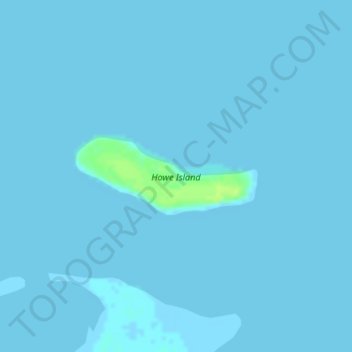
Naam: Topografische kaart Howe Island, hoogte, reliëf.
Locatie: Howe Island, North Slope, Alaska, United States (70.31232 -148.00347 70.31825 -147.96204)
Gemiddelde hoogte: 0 m
Minimale hoogte: -1 m
Maximale hoogte: 11 m
Andere topografische kaarten
Klik op een kaart om zijn topografie, zijn hoogte en zijn reliëf te bekijken.
Wainwright
United States > Alaska > North Slope
Wainwright, North Slope, Alaska, 99782, United States
Gemiddelde hoogte: 5 m
Deadhorse
United States > Alaska > North Slope
Deadhorse, North Slope, Alaska, United States
Gemiddelde hoogte: 15 m
Igloo Mountain
United States > Alaska > North Slope
Igloo Mountain, North Slope, Alaska, United States
Gemiddelde hoogte: 592 m
Prudhoe Bay
United States > Alaska > North Slope
Prudhoe Bay, North Slope, Alaska, 99734, United States
Gemiddelde hoogte: 10 m
Utqiaġvik
United States > Alaska > North Slope
Utqiaġvik, North Slope, Alaska, 99273, United States
Gemiddelde hoogte: 4 m