
Topografische kaart Utqiaġvik
Interactieve kaart
Klik op de kaart om de hoogte weer te geven.
Over deze kaart
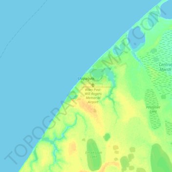
Naam: Topografische kaart Utqiaġvik, hoogte, reliëf.
Locatie: Utqiaġvik, North Slope, Alaska, 99273, United States (71.23029 -156.92450 71.34026 -156.63934)
Gemiddelde hoogte: 4 m
Minimale hoogte: 0 m
Maximale hoogte: 18 m
Despite the extreme northern location, temperatures at Utqiaġvik are moderated by the surrounding topography. The Arctic Ocean is on three sides, and flat tundra stretches some 200 miles (300 km) to the south. There are no wind barriers or protected valleys where dense cold air can settle or form temperature inversions in the lower atmosphere, as commonly happens in the interior between the Brooks and the Alaska ranges.
Andere topografische kaarten
Klik op een kaart om zijn topografie, zijn hoogte en zijn reliëf te bekijken.
Wainwright
United States > Alaska > North Slope
Wainwright, North Slope, Alaska, 99782, United States
Gemiddelde hoogte: 5 m
Howe Island
United States > Alaska > North Slope
Howe Island, North Slope, Alaska, United States
Gemiddelde hoogte: 0 m
Deadhorse
United States > Alaska > North Slope
Deadhorse, North Slope, Alaska, United States
Gemiddelde hoogte: 15 m
Igloo Mountain
United States > Alaska > North Slope
Igloo Mountain, North Slope, Alaska, United States
Gemiddelde hoogte: 592 m
Prudhoe Bay
United States > Alaska > North Slope
Prudhoe Bay, North Slope, Alaska, 99734, United States
Gemiddelde hoogte: 10 m