
Topografische kaart Champaign County
Interactieve kaart
Klik op de kaart om de hoogte weer te geven.
Over deze kaart
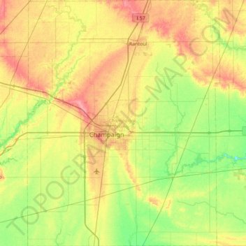
Naam: Topografische kaart Champaign County, hoogte, reliëf.
Locatie: Champaign County, Illinois, United States of America (39.87910 -88.46357 40.40068 -87.92882)
Gemiddelde hoogte: 217 m
Minimale hoogte: 187 m
Maximale hoogte: 260 m
The topography of Champaign County was formed by the Wisconsin Glacier about 20,000 years before the present. Lobes of ice from what is now Lake Michigan crossed the county, creating a deep pile of glacial soil, up to 300 feet thick, topped by numerous moraines forming small, flat watersheds with no outlets.
Andere topografische kaarten
Klik op een kaart om zijn topografie, zijn hoogte en zijn reliëf te bekijken.
Marshall County
United States of America > Illinois
Marshall County, Illinois, United States of America
Gemiddelde hoogte: 201 m
Richland County
United States of America > Illinois
Richland County, Illinois, United States of America
Gemiddelde hoogte: 145 m
Monroe County
United States of America > Illinois
Monroe County, Illinois, United States of America
Gemiddelde hoogte: 157 m
Springfield
United States of America > Illinois > Springfield
Springfield, Sangamon County, Illinois, United States of America
Gemiddelde hoogte: 178 m
Vergennes
United States of America > Illinois > Vergennes > Vergennes
Vergennes, Jackson County, Illinois, United States of America
Gemiddelde hoogte: 121 m
Gallatin County
United States of America > Illinois
Gallatin County, Illinois, United States of America
Gemiddelde hoogte: 122 m
DeKalb County
United States of America > Illinois
DeKalb County, Illinois, United States of America
Gemiddelde hoogte: 253 m
Henry County
United States of America > Illinois
Henry County, Illinois, United States of America
Gemiddelde hoogte: 214 m
Alexander County
United States of America > Illinois
Alexander County, Illinois, United States of America
Gemiddelde hoogte: 112 m