
Topografische kaart Marshall County
Interactieve kaart
Klik op de kaart om de hoogte weer te geven.
Over deze kaart
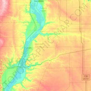
Naam: Topografische kaart Marshall County, hoogte, reliëf.
Locatie: Marshall County, Illinois, United States of America (40.92143 -89.63963 41.14870 -89.04675)
Gemiddelde hoogte: 201 m
Minimale hoogte: 131 m
Maximale hoogte: 292 m
Andere topografische kaarten
Klik op een kaart om zijn topografie, zijn hoogte en zijn reliëf te bekijken.
Richland County
United States of America > Illinois
Richland County, Illinois, United States of America
Gemiddelde hoogte: 145 m
Monroe County
United States of America > Illinois
Monroe County, Illinois, United States of America
Gemiddelde hoogte: 157 m
Springfield
United States of America > Illinois > Springfield
Springfield, Sangamon County, Illinois, United States of America
Gemiddelde hoogte: 178 m
Vergennes
United States of America > Illinois > Vergennes > Vergennes
Vergennes, Jackson County, Illinois, United States of America
Gemiddelde hoogte: 121 m
Gallatin County
United States of America > Illinois
Gallatin County, Illinois, United States of America
Gemiddelde hoogte: 122 m
DeKalb County
United States of America > Illinois
DeKalb County, Illinois, United States of America
Gemiddelde hoogte: 253 m
Henry County
United States of America > Illinois
Henry County, Illinois, United States of America
Gemiddelde hoogte: 214 m
Alexander County
United States of America > Illinois
Alexander County, Illinois, United States of America
Gemiddelde hoogte: 112 m
Champaign County
United States of America > Illinois
Champaign County, Illinois, United States of America
Gemiddelde hoogte: 217 m