
Topografische kaart Odin
Interactieve kaart
Klik op de kaart om de hoogte weer te geven.
Over deze kaart
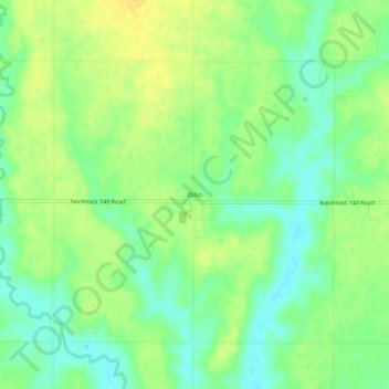
Naam: Topografische kaart Odin, hoogte, reliëf.
Locatie: Odin, Barton County, Kansas, 67525, United States (38.54612 -98.62869 38.58612 -98.58869)
Gemiddelde hoogte: 565 m
Minimale hoogte: 552 m
Maximale hoogte: 576 m
Andere topografische kaarten
Klik op een kaart om zijn topografie, zijn hoogte en zijn reliëf te bekijken.
Beaver
United States > Kansas > Barton County
Beaver, Barton County, Kansas, United States
Gemiddelde hoogte: 583 m
Dubuque
United States > Kansas > Barton County
Dubuque, Barton County, Kansas, United States
Gemiddelde hoogte: 572 m
Ellinwood
United States > Kansas > Barton County
Ellinwood, Barton County, Kansas, 67526, United States
Gemiddelde hoogte: 547 m
Hoisington
United States > Kansas > Barton County
Hoisington, Barton County, Kansas, 67544, United States
Gemiddelde hoogte: 562 m
Great Bend
United States > Kansas > Barton County
Great Bend, Barton County, Kansas, 67530, United States
Gemiddelde hoogte: 570 m
Cheyenne Bottoms
United States > Kansas > Barton County
Cheyenne Bottoms, Barton County, Kansas, United States
Gemiddelde hoogte: 555 m
Barton Lake
United States > Kansas > Barton County
Barton Lake, Barton County, Kansas, United States
Gemiddelde hoogte: 576 m