
Topografische kaart Great Bend
Interactieve kaart
Klik op de kaart om de hoogte weer te geven.
Over deze kaart
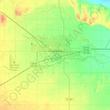
Naam: Topografische kaart Great Bend, hoogte, reliëf.
Locatie: Great Bend, Barton County, Kansas, 67530, United States (38.33027 -98.88497 38.38372 -98.69708)
Gemiddelde hoogte: 570 m
Minimale hoogte: 549 m
Maximale hoogte: 593 m
Great Bend is located at 38°21′52″N 98°45′53″W / 38.36444°N 98.76472°W / 38.36444; -98.76472 (38.3644567, -98.7648073) at an elevation of 1,850 feet (564 m). Located in central Kansas at the intersection of U.S. Route 281 and U.S. Route 56, Great Bend is 95 miles (153 km) northwest of Wichita, 235 miles (378 km) west-southwest of Kansas City, and 345 miles (555 km) east-southeast of Denver.
Andere topografische kaarten
Klik op een kaart om zijn topografie, zijn hoogte en zijn reliëf te bekijken.
Beaver
United States > Kansas > Barton County
Beaver, Barton County, Kansas, United States
Gemiddelde hoogte: 583 m
Dubuque
United States > Kansas > Barton County
Dubuque, Barton County, Kansas, United States
Gemiddelde hoogte: 572 m
Odin
United States > Kansas > Barton County
Odin, Barton County, Kansas, 67525, United States
Gemiddelde hoogte: 565 m
Ellinwood
United States > Kansas > Barton County
Ellinwood, Barton County, Kansas, 67526, United States
Gemiddelde hoogte: 547 m
Hoisington
United States > Kansas > Barton County
Hoisington, Barton County, Kansas, 67544, United States
Gemiddelde hoogte: 562 m
Cheyenne Bottoms
United States > Kansas > Barton County
Cheyenne Bottoms, Barton County, Kansas, United States
Gemiddelde hoogte: 555 m
Barton Lake
United States > Kansas > Barton County
Barton Lake, Barton County, Kansas, United States
Gemiddelde hoogte: 576 m