
Topografische kaart Mars Hill
Interactieve kaart
Klik op de kaart om de hoogte weer te geven.
Over deze kaart
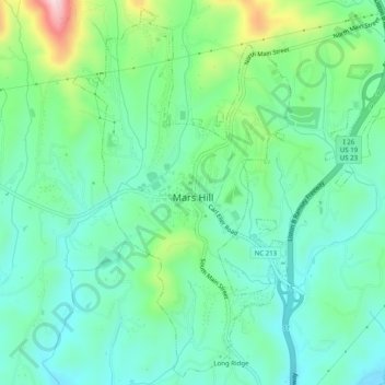
Naam: Topografische kaart Mars Hill, hoogte, reliëf.
Locatie: Mars Hill, Madison County, North Carolina, United States (35.80751 -82.56435 35.84627 -82.51453)
Gemiddelde hoogte: 708 m
Minimale hoogte: 625 m
Maximale hoogte: 942 m
Andere topografische kaarten
Klik op een kaart om zijn topografie, zijn hoogte en zijn reliëf te bekijken.
Marshall
United States > North Carolina > Madison County
Marshall, Madison County, North Carolina, United States
Gemiddelde hoogte: 609 m
Hot Springs
United States > North Carolina > Madison County
Hot Springs, Madison County, North Carolina, United States
Gemiddelde hoogte: 569 m
Barnard
United States > North Carolina > Madison County
Barnard, Madison County, North Carolina, United States
Gemiddelde hoogte: 601 m
Mars Hill
United States > North Carolina > Madison County > Mars Hill
Mars Hill, Madison County, North Carolina, United States
Gemiddelde hoogte: 708 m
Hot Springs
United States > North Carolina > Madison County > Hot Springs
Hot Springs, Madison County, North Carolina, United States
Gemiddelde hoogte: 641 m