
Topografische kaart Fairway
Interactieve kaart
Klik op de kaart om de hoogte weer te geven.
Over deze kaart
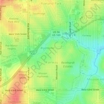
Naam: Topografische kaart Fairway, hoogte, reliëf.
Locatie: Fairway, Johnson County, Kansas, United States (39.01509 -94.63977 39.03463 -94.61582)
Gemiddelde hoogte: 290 m
Minimale hoogte: 263 m
Maximale hoogte: 317 m
Andere topografische kaarten
Klik op een kaart om zijn topografie, zijn hoogte en zijn reliëf te bekijken.
Lenexa
United States > Kansas > Johnson County
Lenexa, Johnson County, Kansas, United States
Gemiddelde hoogte: 301 m
Overland Park
United States > Kansas > Johnson County
Overland Park, Johnson County, Kansas, United States
Gemiddelde hoogte: 300 m
Lenexa
United States > Kansas > Johnson County > Lenexa
Lenexa, Johnson County, Kansas, 66219, United States
Gemiddelde hoogte: 290 m
Leawood
United States > Kansas > Johnson County
Leawood, Johnson County, Kansas, United States
Gemiddelde hoogte: 289 m
Overland Park
United States > Kansas > Johnson County > Overland Park
Overland Park, Johnson County, Kansas, 66204, United States
Gemiddelde hoogte: 288 m
Prairie Village
United States > Kansas > Johnson County
Prairie Village, Johnson County, Kansas, United States
Gemiddelde hoogte: 300 m
Olathe
United States > Kansas > Johnson County > Olathe
Olathe, Johnson County, Kansas, 66061, United States
Gemiddelde hoogte: 302 m
Olathe
United States > Kansas > Johnson County
Olathe, Johnson County, Kansas, United States
Gemiddelde hoogte: 309 m